")


hautes alpes
-
102 Via Ferrata Pra Premier, Arvieux, Hautes-Alpes, France
Via Ferrata Pra Premier, Arvieux, Brunissard, Hautes-Alpes
Passerelle Pont Népalais Echelle Tyrolienne 0 0 1 0 Caractéristiques
Elle se fait sur une belle paroi triangulaire en calcaire compacte et verticale. Pas de grande difficulté technique mais «tire bras» et un peu de gaz sur la fin.
Possible pour les débutants accompagnés.
 Astuces ViaFerrata
Tu as une option de parquer ta voiture au parking de Premier (2'050 m)
Tu peux monter en voiture sur la route non goudronnée mais interdite aux nons initiés . Tu arrives au stationnement de Pré Premier.
Il y a une possibilité de grouper avec la Via Ferrata La Crête de Combe La Roche. Tu termines par Pra-Premier qui est sur le chemin de descente. Mais bon, il faut être un sacré gaillard!
Cotation
Physique 2 Gaz 3 Type Haute-Montagne: 2 Technique 1 Evaluation Assez Difficile Information
Office du Tourisme Arvieux
Si tu reçois une réponse e-mail de l'Office du Tourisme, garde-le car il vaut une fortune! Nous avons essayé, pas l'ombre d'un signe de vie.
 Longueur & Altitudes
Altitude départ: 2'120 m
Arrivée de la via: 2'320 m
Dénivelation: 200 m
Longueur: 400 mCoordonnée GPS
.
Période
Dès qu'il n'y a plus de neige (mai/juin à octobre/novembre)
Horaire
Approche de la via: 30 min depuis le parking du bas
Via Ferrata: 1h30
Retour: 20 min. Par la route
Sur la D902 jusqu'à Arvieux.
 Par le Train
Voir avec la SNCF pour les bus et train.
 Accès
AccèsA la sortie d'Arvieux, tu prends la direction du Col de l'Isoard. A Brunissard, tu trouves un camping.
Le chemin part du parking à proximité du Cirque de Pra Premier. Tu as un sentier sur la gauche qui est balisé. Le départ de la Via Ferrata se trouve au fond du plateau derrière le lac artificiel.
Via Ferrata
La via débute un peu les doigts dans le nez. Tu grimpes dans un mur vertical. Ensuite une échelle te permet d'éviter un surplomb.
Tu passes, sur ta gauche, un passage en traversée pour te retrouver au coeur de la paroie pour attaquer une montée raide qui arrive dans une partie herbeuse.
Tu termines le tout par un passage aérien et qui est parfois humide en cas de pluie ou au printemps et en automne. Tu peux éviter cette dernière partie de 50m par un échappatoire.
Retour
Tu trouves les caïrns et le sentier jusqu’aux chalets de Clapeyto.
Sur ta gauche tu trouves le sentier qui descend dans le vallon de la Selle Vielle, au départ de la via ferrata, ou sur ta droite, tu as la route de La Casse qui te mène jusqu’au parking.
 Ou dormir
Vori avec l'Office du Tourisme.
Medias
par Jasmienes, Youtube -
-
111 Via Ferrata La Crête de Combe La Roche, Arvieux, Hautes-Alpes, France
Via Ferrata La Crête de Combe La Roche, Arvieux Brunissard, Hautes-Alpes
Passerelle Pont Népalais Echelle Tyrolienne 0 0 0 0 Caractéristiques
Via ferrata qui offre du gaz et qui est très sportive. Débute par un mur très raide, dès le départ. Assez peu de matos et pas mal de contacts avec les rochers.
Pas de fioriture. Du muscle.
Astuces ViaFerrataTu peux coupler cette via avec celle de Pra Premier. Celle-ci se trouve sur le chemin de retour.
Avant de partir, regarde la météo car tu te trouves en haute-montagne et surtout de bonnes chaussures avec semelles vibram (pas de basket même si Killian Jornet est ta vedette)
Cotation
Physique 3 Gaz 4 Type Haute-Montagne: 2 Technique 1 Evaluation Très difficile Information
Office du Tourisme de Arvieux- Isoard
Pas les plus lestes à répondre via e-mail.
Longueur & AltitudesAltitude départ: 2'121 m
Arrivée de la via: 2'440 m
Dénivelation via: 319 m
Longueur: 460 mCoordonnée GPS
.
Période
Dès qu'il n'y a plus de neige (mai - octobre)
Horaire
Approche de la via: 20 minutes
Via Ferrata: 2h
Retour: 45 minutes.Par la routeSur la D902 jusqu'à Arvieux - Brunissard
Par le TrainVoir avec la SNCF pour les bus et train.
AccèsA la sortie d'Arvieux, tu prends la direction du Col de l'Isoard. A Brunissard, tu trouves un camping, tu le traverses et continues en direction des Chalets de Clapeyto. Ta voiture t'attendras au parking "Pré des Vaches" en face du cirque de Pra-Premier. Il te faut suivre sur la gauche le sentier balisé d’accès à la retenue d’eau jusqu’au départ de la Via Ferrata.
Via Ferrata
Tu as dans tes mains une Via Ferrata sportive et très aérienne. Elle débute par un mur très raide pour arriver sur une partie un peu plus relaxe.
La traversée continue sur la gauche pour aboutir au centre de la paroi, sous des murs surplombants, avec des passages aériens sans beaucoup de marches. Tu as du contact avec le rocher. C'est assez sportif. La difficulté vient de l'équipement assez somaire. Tu peux t'aider du câble si tu n'arrives pas à progresser, mais normalement si tu cherches bien, tu dois faire sans.
Retour
Au sommet, tu arrives dans les alpages de Clapeyto. Tu trouves une piste pour redescendre au parking ou pour faire la via ferrata de Pra Premier, s'il te reste du jus.
Ou dormirVoir avec l'Office du Tourisme.
Photos
par Chaîne de zebrprod, Youtube -
-
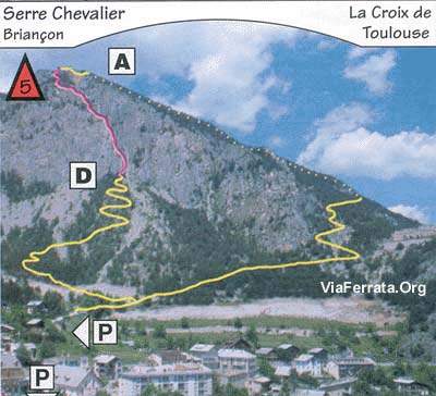
15 Via Ferrata Croix de Toulouse, Briancon, Hautes Alpes, France
Via Ferrata Croix de Toulouse Briancon, Hautes Alpes
Passerelle Pont Singe Echelle Tyroliennes 1 x 1 m 0 0 0 Caractéristiques
A conseiller aux débutants et à ceux qui ne veulent pas se faire peur.
Conseils ViaFerrataExposition plein sud, soit la faire le tôt le matin soit prendre à boire, de la crème solaire et des lunettes de soleil.
Très fréquentée en été, mieux vaut éviter certains week-ends.
Cotation
Physique 1 Gaz 2 Type Haute Montagne: 1 Technique 2 Evaluation Pour Débutant, Initiation Information
Office du tourisme de Briançon
Longueur et AltitudeDépart : 1'290 m
Arrivée 1'962 m
Longueur : 370 m
Dénivelée : + 672 mCoordonnée GPS
Période
Avril à Novembre
Horaire
40 minutes d'approche
Via Ferrata 1 à 2 heures
La descente est raide mais équipée. Compte 40 minutes.Par la routeDe Grenoble, prendre la N 91 en direction du col du Lautaret pour atteindre Briançon.
Par le TrainVoir avec la SNCF: horaires et tarifs
AccèsParque ta voiture au parking du Champ de Mars, au-dessus de la cité Vauban. Remonte sur 500m une petite route vers la falaise bien visible, jusqu'à une citerne d'eau (panneau).
Suis un sentier balisé. La via ferrata débute au pied de l'arrête sud-est.
Compte au total 30 min de marche pour atteindre le départ qui se trouve dans un couloir à gauche des voies d'escalades.Via Ferrata
L'itinéraire câblé commence par une série de vires et de petits murs. Quand c'est raide, de nombreux échelons permettent d'être toujours en confiance. Après le premier tiers, c'est la passerelle du Président (au choix le fromage ou celui qui est à Paris). Pas de problème, elle fait un mètre de large et il y a plus impressionnant.
Ensuite tu continues, Briançon à tes pieds, avec pas mal de portions de marche.Un bon casse-croûte au sommet te récompensera de tes efforts. Au retour, tu passes devant le Fort des Salettes et direction le parking.
Retour
Très simple.
Où dormirGîte d'étape du Fontenil
par Chaîne de zebrprod, Youtube
Photos
-
-
15e Via Ferrata Croix de Toulouse, Briancon, Hautes Alpes, France
Via Ferrata Croix de Toulouse, Briancon, Hautes Alpes
Footbridge Monkey Bridge Ladder Zipline 1 x 1m 0 0 0 Features
Recommended for beginners and those who don't want to get scared.
Conseils ViaFerrata Tips and TricksFully south facing, either go early in the morning or bring enough water, sunscreen, and sunglasses.
Very popular during the summer, it's better to avoid certain weekends.
Grade
Strength 1 Dizziness 2 Type High Mountain: 1 Technics 2 Evaluation For Beginner, Initiation Information
Length and AltitudeStart : 1,290 m
End: 1,962 m
Length : 370 m
Elevation gain : + 672 mTime of Year
April to when the snow starts to fall.
Timing
40 minutes of approach
Via Ferrata: 1 to 2 hours
The way down is steep but equipped. About 40 minutes.By CarFrom Grenoble take N91 towards the Lautaret pass to get to Briançon.
By TrainCheck with the SNCF: schedules and fares
AccessPark your car in the Champ de Mars parking lot, above the city of Vauban. Go up 500m on a small road near the very visible cliff face until you reach a water tank (sign).
Follow a marked trail. The via ferrata starts at the base of the south-east arrête.
It takes about 30 minutes to walk to the start which is found in a couloir to the left of the climbing routes.Via Ferrata
The cabled itinerary starts off with a series of ledges and little walls. When it's steep there are always more than enough rungs to keep you at ease. After the first third you go across the President's footbridge (your choice- the brand of cheese or the one in Paris). No problem, it's a meter wide and much scarier sections exist in the world of via ferratas.
Then you keep going with Briançon beneath you, there are quite a few walking sections.A good snack at the top will reward you for your efforts. On the way back you pass by the Salettes Fort and then continue on towards the parking.
Way Back
Very simple.
Where to Spend the NightMedia
par Chaîne de zebrprod, Youtube
-
-
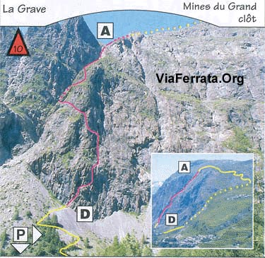
16e Via Ferrata Mines du Grand Clos, La Grave, Hautes Alpes, France
Via Ferrata Mines du Grand Clos, La Grave, Hautes-Alpes
Footbridge Monkey Bridge Ladder Zipline 0 0 0 0 Features
A very long via ferrata: 2km of cable. Lots of contact with the rock.
ViaFerrata Tips and TricksMake sure you take enough food and water for a full day in the mountains.
If you can leave your car at Chazalet, do so as it will make the way back shorter. You'll save an hour. But then again, what is one hour compared to all of life?
Grade
Strength 3 Dizziness 2 Type High-Mountain: 3 Technics 1 Evaluation Difficult (long) Information
La Grave Tourism Office
Length and AltitudeStart: 1,328 m
End: 2,100 m
Elevation gain: 750 m
Cable length: 2000 m.Time of Year
April - November.
Timing
5 minutes for the approach
3 to 5 hours for the via ferrata
2 heures of downhill or 1 hour if your car is at Chezalet.By CarFrom Grenoble go towards Briançon by going over the Lautaret pass. The parking lot is at Le Grand Clos (1,328m), 3km before the village of la Grave. There is an information pannel.
By Train or BusTake the train to Annecy and then the bus. Check with the SNCF: schedules and fares.
Access3 minutes from the road.
Via Ferrata
Several steep sections in the first 300m, but the hardest thing about this via ferrata is that it is long and there are no escape rights.
The section in the chimney is certainly the nicest part.THe last part is a kind of rock climb and via ferrata, but the more you climb, the less steep it gets.
Bring a map of the area with you as it may be useful for the way back.Way Back
By car if you can leave your car at Chazelet (GR54)
Where to Spend the NightThere are many lodges around la Grave and Chazelet. There are campgrounds and hotels in la Grave and in Fréaux.
Media
vidéo par Sepukangri, Youtube
-
-
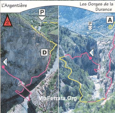
18 La Balme et Colombier Les Vigneaux Hautes Alpes France
Via Ferrata la Balme et le Colombier, Les Vigneaux, Hautes Alpes
Passerelle Pont de singe Echelle Tyrolienne 0 0 1 x inversée 0 Caractéristiques
2 via ferrata avec le même départ et le chemin se sépare en deux.
Très beaux panorama sur les Écrins.
Après une courte montée, cette Via ferrata se sépare en deux partie: La via ferrata de la Balme (celle de droite) et la Via Ferrata du Colombier (la voie de gauche, plus facile).
Conseils ViaFerrata
Pas vraiment pour les débutants à cause du gaz
Cotation
Physique Colombier
Balme2
4Gaz Colombier
Balme2
3Type Colombier
BalmeMontagne 1
Montagne 2Technique Colombier
Balme1
1Total Colombier
BalmeD
TDInformation
Office du Tourisme d'Argentières
Office du Tourisme de Vallouise (pas encore de site internet)
Longueur et AltitudeDépart: 1'150 m,
Arrivée 1'650 m
Longueur: 380 mCoordonnée GPS
Latitude: 44.8167 / Longitude: 6.53333
Période
Toute l'année
Horaire
Le Colombier: 1 heure
Les Balmes: 2 heures
Descente: 1h30Par la routeDe Briançon, prendre au sud de la N94 vers Embrun.
A 8 km, à Prelles, prendre à droite la D4 vers les Vigneaux, 8 km, et Vallouise. Ou continue sur la N94 et vas jusqu'à Argentière-la-Bessée et là, à droite, la D 994 vers les Vigneaux et Vallouise. Le deuxième accès est plus roulant.
Par le TrainVoir avec la SNCF: horaires et tarifs
AccèsLaisse ta voiture au bout du village. Le chemin est évident vers la falaise calcaire, orientation sud-ouest, 15 minutes de marche agréable.
Via Ferrata
La première partie est commune aux deux via ferrata d’un niveau facile. Arrivé à un croisement, tu as deux options:
Du côté où tu as la montre: la via du Colombier
Passage assez facile avec beaucoup de marches et d’appuisDu côté où tu as le pouce à gauche: la via de la Balme
Un viaferrata plus en dévers avec des surplombs et une magnifique vue sur les Vigneaux.
Plus sportive pour les bras et plus longue. Pas pour les débutants
Retour
C’est facile via un bon sentier balisé.
Où dormirpar karibou06, Youtube
Photos
-
-
18e La Balme et Colombier, Les Vigneaux, Hautes Alpes, France
Via Ferrata la Balme et le Colombier Les Vigneaux Hautes Alpes
Footbridge Monkey Bridge Ladder Zipline 0 0 1 0 Features
2 via ferratas that start at the same point, the trail then splits in two.
Beautiful panorama of the Écrins.
After a short uphill this Via Ferrata splits into two parts: The Balme Via Ferrata (on the right) and the Colombier Via Ferrata (on the left, the easier of the two).
ViaFerrata Tips and Tricks
Not really for beginners because of the void
Grade
Strength Colombier
Balme2
4Dizziness Colombier
Balme2
3Type Colombier
BalmeMountain: 1
Mountain: 2Technics Colombier
Balme1
1Evaluation Colombier
BalmeDifficult
Very DifficultInformation
Tourisme d'Argentières Tourism Office
Length and AltitudeStart: 1,150 m
End: 1,650 m
Length: 380 mGPS Coordinates
Latitude: 44.8167 / Longitude: 6.53333
Time of Year
All year
Timing
Le Colombier: 1 hour
Les Balmes: 2 hours
Way back: 1h30By CarFrom Briançon, go south from N94 towards Embrun.
8km further, in Prelles, go right from D4 towards Vigneaux, then another 8km and you reach Vallouise. Or you can keep going on N94 to Argentière-la-Bessée, here go right, take D994 towards les Vigneaux and Vallouise. The second route is more bumpy.
By TrainCheck with the SNCF: schedules and fares
AccessLeave your car at the end of the village. The trail is easy to find - near the limestone cliff, southwest facing - it's a nice 15 minutes walk.
Via Ferrata
The first section is easy and part of both via ferratas. Once you get to the junction you have two options:
The side where you wear your watch: Colombier Via Ferrata
An easy section with lots of steps and supportThe side where your thumb is on the left: Balme Via Ferrata
This via ferrata is more sloped and has some overhanging sections and a magnificent view of the Vigneaux.It's more demanding and made for those with longer arms. Not for beginners.
Way Back
It's easy, there's a good marked trail.
Where to Spend the NightAsk the Tourism Office
Media
par karibou06, Youtube
-
-
20 Via Ferrata de Tournoux, Puy St-Vincent, Hautes Alpes, France
Via Ferrata de Tournoux, Puy St-Vincent, Hautes Alpes

Passerelle Pont de bois Echelle Tyrolienne 0 0 0 0 Caractéristiques
Accessible aux débutants très bien accompagnés. Aérienne, elle propose quelques passages athlétiques mais assez courts.
La montée présente quelques passages athlétiques mais ils sont courts. Cette via est un circuit montée/descente. Le tout pour le même prix !
Conseils ViaFerrataLa via est à l'ombre, ce qui est chouette durant les fortes chaleurs en été. Cependant, prends un truc anti-moustique ou du Tégarome (c'est un produit qui calme les piqures d'insectes. Comme c'est un produit naturel, bon-marché, qui fonctionne super bien, les entreprises chimiques l'ont interdit en Suisse).
Prends une petite laine car elle située au nord, donc c’est pas ici que tu va bronzer
Cotation
Physique 2 Gaz 1 Type 1 Technique Haute-Montagne: 1 Evaluation Peu Difficile Information
Office du tourisme de Puit-St-Vincent
Longueur et AltitudeDénivelé : 180 m.
Départ : 1750 m.
Orientation : Nord.
Roche : calcaire.
Longueur de la Via : 600 m.Coordonnée GPS
Période
Mai à octobre
Horaire
Accès: 10 minutes
Viaferrata : 1 heure 30.
Retour : 20 minutesPar la routeVenant du nord, autoroute jusqu'à Grenoble, puis col du Lautaret RN 91. Traverse Briançon en direction de Gap.
A l'Argentière La Bessée, tourne à droite direction Vallouise, Puy St Vincent est à 10 km.
Venant du Sud, autoroute jusqu'à la Saulce, puis direction Briançon RN 94.
A l'Argentière La Bessez, tourne à gauche, direction Vallouise, Puy St Vincent est à 10 Km.Par le Train ou le BusGare de l'Argentière les Ecrins, à 10 km de Puy St Vincent. Voir avec la SNCF: horaires et tarifs.
AccèsA Puy Saint Vincent 1'400, au dessus de la Vallouise, prends la route de la Pousterle, (qui devient non-goudronnée).
Parque avant le grand replat au col.
Ensuite, prends le sentier à droite qui se dirige vers Tournoux. La Via est indiquée par un panneau.Via Ferrata
Elle est bien équipée et parfois aérienne avec de courts moments d'efforts intenses.
La première partie débute par un mur vertical athlétique et aérien avant d’arriver vers un sentier plein de verdure et une descente câblée.
Ensuite, quelques passages raides dans un nouveau mur bien raide pour te refaire une descente un instant après. Tu as l’occasion de voir une grotte, fais un vœux !
Un nouveau mur donne l'accès à une descente sur la droite et tu rejoins le pied de la falaise.
Au sommet, tu découvres un très beaux panoramas sur les Ecrins et la Vallouise
Retour
Du pied de la falaise rejoindre facilement le chemin principal en contrebas et remonter au col de La Pousterle.
Où dormirRegarde avec l'Office du Tourisme.
vidéo par Zebrprod, Youtube
Photos
-
-
20e Via Ferrata de Tournoux, Puy St-Vincent, Hautes Alpes, France
Via Ferrata de Tournoux, Puy St-Vincent, Hautes Alpes
Footbridge Monkey Bridge Ladder Zipline 0 0 0 0 Features
Okay for beginners who are guided by an experienced person. Vertiginous and with several demanding sections, but they are fairly short.
This via ferrata is a loop- up/down. All for the same price!
ViaFerrata Tips and TricksThis via ferrata is in the shade, which is nice during summer heatwaves. However, make sure you take some mosquito repellent or Tégarome (a product that soothes insect bites). It's a natural product, cheap, and works well, however chemical companies in Switzerland have banned it.
Take an extra layer because it faces north, thus you won't be tanning here either
Grade
Physique 2 Gaz 1 Type 1 Technique Haute-Montagne: 1 Evaluation Peu Difficile Information
Puit-St-Vincent Tourism Office
Length and AltitudeElevation gain : 180 m.
Start : 1750 m.
Exposure : North
Rock : limestone
Length of the Via Ferrata : 600 m.Time of Year
May to October
Timing
Access: 10 minutes
Viaferrata : 1 hr 30
Way back : 20 minutesBy CarIf you're coming from the north take the highway to Grenoble, then the Lautaret pass, RN 91. Go across Briançon towards Gap.
In l'Argentière la Bessée go right towards Vallouise, Puy St Vincent is 10km away.If you are coming from the South, take the highway to Saulce, then go towards Briançon, RN 94.
In l'Argentière La Bessez, go left towards Vallouise, Puy St Vincent is 10km away.By Train or Busl'Argentière les Ecrins train station, 10 km from Puy St Vincent. Check with the SNCF: schedules and fares.
AccessIn Puy Saint Vincent at 1'400m, above Vallouise, take the Pousterle road (which becomes an unpaved road).
Park before the big flat area on the pass.
Then take the trail that goes right towards Tournoux. The Via Ferrata is marked with a sign.Via Ferrata
It is well equipped and sometimes vertiginous with some short sections of intense effort.
The first part starts off with a tough and vertiginous vertical wall before you get to a path full of greenery and a cabled descent.
Then several steep sections on a very steep wall and all that to go back down again right after. You'll have the opportunity to see a cave, make a wish!
A new wall lets you go down on the right and you get back to the base of the cliff face.
At the summit you will discover a beautiful panorama of the Ecrins and Vallouise
Way back
From the base of the cliff you can easily get back to the main trail below and then go back up to the Pousterle pass.
Where to Spend the NightCheck with the Tourism Office.
vidéo par Zebrprod, Youtube
Media
-
-
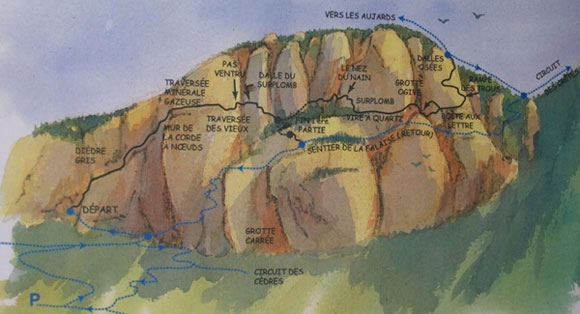
21 Via Ferrata de la Grande Falaise, Freissinières, Hautes Alpes, France
Via Ferrata de la Grande Falaise, Freissinières, Hautes Alpes
Passerelle Pont de Singe Echelle Tyroliennes 0 0 0 0 Caractéristiques
La toute première via ferrata en France. Elle fait partie de l'Histoire avec un grand H et du grand Gaz avec une forte impression de vide dans certains passages
Construite par Lionel Condemine en 1988.En deux parties.
Conseils ViaFerrataBeaucoup de contacts avec les rochers et pas une tapée de barreaux. Prendre des bonnes chaussures.
Cotation
Physique 3 Gaz 3 Type montagne: 3 Technique 1 Evaluation Difficile Information
Office du tourisme de Freissinières
Longueur et AltitudeDépart: 1'333 m
Arrivée 1'650 m
Longueur 1'600 m.Coordonnée GPS
Latitude: 44.75
Longitude: 6.533
Période
Avril à Novembre
Horaire
1h30 à 2 heures pour la première partie, 3 à 4 heures pour l'ensemble.
Par la routeFreissinière, situé dans la vallée du même nom, appartient au massif des Ecrins.
Depuis la N 94, entre Briançon et Mont-Dauphin, vers la Roche de Rame prendre la D 38 jusqu'au hameau de Pallon, puis la D 238B jusqu'au village de Freissinières.
Traverse le village et continue sur quelques centaines de mètres. Le parking est en bord de route, dans une épingle. Pas très grand, ce parking requiert discipline et courtoisie les jours d'affluence. Comme ces deux caractéristiques ont tendance à foutre le camp, pête un bon coup avant et tout ira bien!
Par le TrainVoir avec la SNCF: horaires et tarifs.
AccèsCompte 30 minutes du parking à la via ferrata. Le sentier (vers l’Est) mène au pied de la falaise des rochers rouges. Prends à gauche pour arriver à la ferrata.
Via Ferrata
Cette Ferrata se veut aérienne et technique, tu n’auras pas toujours les mains sur le métal… Il faudra utiliser le caillou, dans des pas qui frôle le 3+. Tu commences par une escalade un passage rocheux et tu arrive sur une vire horizontale au mur de la Corde à Nœuds, qui mène à la longue Traversée Minérale Gazeuse (passage aériens) avec un superbe panorama. Après la Grotte des Maquisards, le Pas Ventru et la Dalle au Surplomb, quelques passages en désescalade marquent la fin de la 1er partie.
La deuxième partie monte sur un passage boisé sur une terrasse. Tu retrouves la ligne de vie et monte à la Vire aux Quartz et dans une faille pour arriver vers une grotte. Là, tu vas entrer dans la partie la plus aérienne de la via ferrata. Au niveau d’une grande dalle « Dalles Osées » tu entres dans un passage physique et impressionnant. Ensuite ça se termine en roue libre
Le caractère principal réside dans le caractère impressionnant des passages et leur impression de vide.Retour
Une heure pour rejoindre ta titine dans le parking.
La descente se fait par un bon sentier aérien. Sois prudent.Où dormirGîtes les 5 Saisons: 04.92.20.94.40. Hors de France +33 04.92.20.94.40. Vous pourrez y louer du matériel, profiter d'excellent repas et vous reposer tranquillement après l'effort.
Media
par Jasmienes, Youtube -
-
21e Via Ferrata de la Grande Falaise, Freissinières, Hautes Alpes, France
Via Ferrata de la Grande Falaise, Freissinières, Hautes Alpes
Footbridge Monkey Bridge Ladder Zipline 0 0 0 0 Features
The first ever via ferrata in France. It's part of History with a capital "H" and during some parts it's Vertiginous with a large dose of void.
Built by Lionel Condemine in 1988.In two parts.
ViaFerrata Tips and TricksLots of contact with the rock and no bars. Wear proper shoes.
Grade
Strength 3 Dizziness 3 Type Mountain: 3 Technics 1 Evaluation Difficult Information
Length and AltitudeStart: 1,333 m
End: 1,650 m
Length: 1,600 m.GPS Coordinates
Latitude: 44.75
Longitude: 6.533
Time of Year
April to November
Timing
1h30 to 2 hours for the first part, 3 to 4 hours for the whole thing.
By CarFreissinière, located in the valley that goes by the same name, belongs to the Ecrins massif.
From N94, between Briançon and Mont-Dauphin, towards la Roche de Rame take D38 to the hamlet of Pallon, then D 238B to the village of Freissinières.
Cross the village and keep going a couple hundred of meters. The parking lot is on the side of the road, in a hairpin. It's not very big so it requires discipline and courtesy on busy days. As these two features have a tendancy to create havoc, let it out a bit before and everything will be alright!
By TrainCheck with the SNCF: schedules and fares.
AccessIt takes about 30 minutes to get to the via ferrata from the parking lot. The trail (towards the East) leads you to the base of the cliff with red rocks. Go left to get to the ferrata.
Via Ferrata
This Ferrata is vertiginous and techinical, you won't always have your hands on metal...You will have to use the rock, in some steps that come very close to the 3+ grade. You start by climbing a rocky section and then you get to a horizontal ledge on the "Corde à Noeuds" (Rope with Knots) Wall. This leads you to the long "Minérale Gazeuse" (Vertiginous Minerals) Traverse (vertiginous sections) which has a superb panorama. After the Maquisards Grotte, the Pas Ventru, and the "Dalle au Surplomb" (Overhanging Slab), a few sections of downclimbing mark the end of the first part.
The second part goes up a wooded area on a terrace. You find the lifeline again and go up to the "Vire aux Quartz" (Quartz Ledge) and go through a gap to get to a cave. Here you will begin the most vertiginous part of the via ferrata. When you reach a big slab, "Dalles Osées" (Daring Slab), you are in a demanding and impressive section. Then it's all freewheel to the finish.
The main feature of this via ferrata is how impressive and vertiginous some sections are.
Way Back
It takes one hour to get back to your ride in the parking lot.
The way down is a good vertiginous trail. Be careful.Where to Spend the NightGîtes les 5 Saisons: 04.92.20.94.40. Calling from outside of France +33 04.92.20.94.40. You can rent equipment hear, eat excellent meals, and rest peacefully after physical exertion.
Media
par Jasmienes, Youtube -
-
22 Via Ferrata Les Vires des Gorges Agnielles, La Faurie, Hautes Alpes, France
Via Ferrata Les Vires des Gorges Agnielles, La Faurie, Hautes Alpes
Passerelle Pont de bois Echelle Tyrolienne 0 0 0 0 Caractéristiques
2 itinéraires : un facile pour l'initiation; un très sportif. C'est court avec un peu de gaz.
Super pour l'initiation et pour les enfants malgré le vide . Petite falaise mais grosses sensations. Possibilité en final de descendre en rappel, mais là il faut que tu connaisses le concept et la technique et que tu amènes ta corde de 30 mètres au minimum.
Conseils ViaFerrataSi le temps est humide, tu risques de te faire doucher par le ruissellement. Prends de très bonnes chaussures (Vibram) et surtout, mais ça c’est valable dans toutes les via ferrata, tu as ton casque vissé sur ta tête. Les pierres tombent comme les feuilles d’un arbre en automne !
Cotation
Physique Partie 2: 3 Gaz Partie 2: 2 Type Plaine: 1 Technique 1 Evaluation Partie 1: Initiation
Partie 2: Très DifficileInformation
Office du tourisme de Buëch
Longueur et AltitudeItinéraire d'initiation:
Orientation : Est - Longueur : 500mItinéraire Sportif:
Orientation : Est - Longueur : 350mDépart 850 m.
Arrivée : 950 m
Dénivelé : 100 mCoordonnée GPS
Période
Toute l'année
Horaire
Accès: 10 minutes
Viaferrata : 1 heure.
Retour : 30 minutesPar la routeSur le RD 1075 Grenoble / Sisteron, entre la Faurie et Aspres sur Buëch
1 km après Aspres-Sur-Buëch, délaisse le croisement Veynes/Gap et continue sur 500 m, prends à droite la piste forestière des Gorges d’Agnielles sur 1 km, jusqu'au parking. Là, tu poses ta titine.Par le Train ou le BusJusqu'à la Gare de Lignerolles. Voir avec la SNCF: horaires et tarifs.
AccèsTu continues à pieds jusqu’à l’école d’escalade sur 300m. Là, tu as un panneau Via Ferrata.
Tu prends le chemin à gauche en lacet jusqu'au départ.Via Ferrata
Partie 1: Initiation
Ca commence par un petit mur et suit une grande vire aérienne. Tu passes ensuite 2 grottes pour atteindre la vire des hirondelles (sauf au printemps). Tu franchis un nouveau mur vertical, puis une dernière traversée gazeuse qui permet de sortir de l'itinéraire ou de faire un rappel de 30 m (si tu as une corde).
Partie 2: sportif
1ère partie avec passages sportifs. La deuxième partie est très athlétique avec deux vires très aériennes dont une débouche dans une petite grotte faisant suite à un sentier non équipé. Ne pas monter, mais descendre encore quelques mètres pour passer sur la gauche dans une autre grotte que l'on traverse.Le sentier remonte un peu et tu retrouves les équipements pour passer à une autre vire très aérienne.
Retour
De la partie 1: 20 minutes
De la partie 2: tu as deux choix: rejoindre le parking (5 min) ou prolonger l'expérience par le parcours facile
Où dormirGîte d'étape La Chapelle, 15 places à Aspres-sur-Buëch
vidéo par Viaferrataalpes, Youtube
Photos
-
-
22e Via Ferrata Les Vires des Gorges Agnielles, La Faurie, Hautes Alpes, France
Via Ferrata Les Vires des Gorges Agnielles, La Faurie, Hautes Alpes
Footbridge Monkey Bridge Ladder Zipline 0 0 0 0 Features
2 itineraries : an easy one for beginners; a very athletic one. It's short and a bit vertiginous.
Great for an introduction to via ferrata and for kids despite the void. Small cliff big sensations. It's possible to rappel down, but for this you need to know the concept and the technique and you'll have to bring a minimum 30m rope.
ViaFerrata Tips and TricksIf the weather is wet, you might get soaked from the runoff. Wear proper shoes (Vibram) and most important of all, but of course this applies to all via ferratas, your helmet should be glued to your head. The rocks here fall like leaves from autumn trees!
Grade
Strength Part 2: 3 Dizziness Part 2: 2 Type Plaine: 1 Technique 1 Evaluation Part 1: Initiation
Part 2: Very DifficultInformation
Length and AltitudeBeginner's itinerary:
Exposure : East facing - Length: 500mAthletic itinerary:
Exposure : East facing - Length: 350mStart: 850 m.
End : 950 m
Elevation gain : 100 mTime of Year
All year
Timing
Access: 10 minutes
Viaferrata : 1 hour.
Way back : 30 minutesBy CarOn the RD 1075 Grenoble/Sisteron, between la Faurie and Aspres sur Buëch
1km after Aspres-Sur-Buëch, abandon the Veynes/Gap junction and keep going for 500m, go right on the forest track of Gorges d'Agnielles for 1km, until you reach the parking lot. Here you can drop off your wheels.By Train or BusTo the Lignerolles train station. Check with the SNCF: schedules and fares.
AccessKeep going on foot for 300m to the climbing school. Here you'll see a Via Ferrata sign.
Take the trail on the left that switchbacks up to the start.Via Ferrata
Part 1: Initiation
It starts off with a small wall and then a big vertiginous ledge. After 2 caves you get to the vire des "hirondelles" (swallows, but they're not here in the spring). You go up a new vertical wall, and then another vertiginous traverse lets you leave the itinerary or rappel down 30m (if you have a rope).
Part 2: Athletic
The first section is athletic. The second section is very athletic as it has two very vertiginous ledges. One of these leads to a small cave which in turn leads to an unequipped path. Don't climb up, but go down a couple meters to go through another cave on the left.The trail goes back up a little and it is equipped. Then you go to a another very vertiginous ledge.
Way Back
From the first part: 20 minutes
From the second part 2: you have two choices: go back to the parking lot (5 min) or add to the experience by doing the easy section.
Where to Spend the NightGîte d'étape La Chapelle, 15 beds in Aspres-sur-Buëch
Media
vidéo par Viaferrataalpes, Youtube
-
-
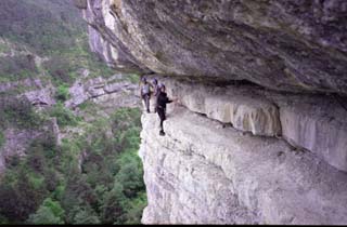
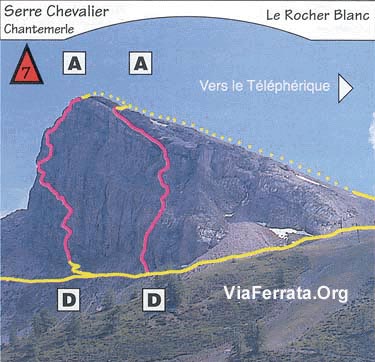
30e Via Ferrata Rocher du Bez, Serre Chevalier, Hautes Alpes, France
Via Ferrata Rocher du Bez, Serre Chevalier, Hautes Alpes
Footbridge Monkey Bridge Ladder Zipline 0 0 0 0 Features
For first-timers and children. In one part of the via ferrata the rungs are purposefully closer together for children.
You will find two via ferratas. "L'Ancienne" ("The Ancient") is easy and in two parts with a "crevasse" section in the middle of the cliff.
ViaFerrata Tips and TricksAt the beginning of the season, check to see if the road is accessible for cars. Sometimes it is flooded with water.
Grade
Strength 1 Dizziness 1 Type High Mountain: 2 Technics 1 Evaluation Easy Information
Serre Chevalier Tourism Office
Length and AltitudeStart : 1,620 m
End : 1,720
Elevation gain : 100m
Length : 350 mTime of Year
Check with the tourism office.
Timing
Approach : 20 min
Via ferrata : 1h00
Way back : 20 minBy CarGo past Serre-Chavalier. La via ferrata is found in the commune of Villeneuve la Salle
By Train or BusCheck with the SNCF. schedules and fares.
AccessDans la commune de Villeneuve la Salle, tu vas suivre la rivière jusqu'au parking du Parc Aventure. Tu continues pour te parquer 200m plus haut.
Le panneau de la via ferrata est sur ta droite.Via Ferrata
This via ferrata is made up of 2 parts or 2 via ferratas, whichever you prefer.
The first one is very easy for children or beginners and you will pass through the guts of the cliff.
The second one starts to the left of the climbing rock. It is a bit more vertiginous, but it is accessible for all.
Way Back
The approach walk and the way back can both seem long.
Where to Spend the NightCheck with the Tourism Office
Media
vidéo par David Cracou, Youtube


