Switzerland
-
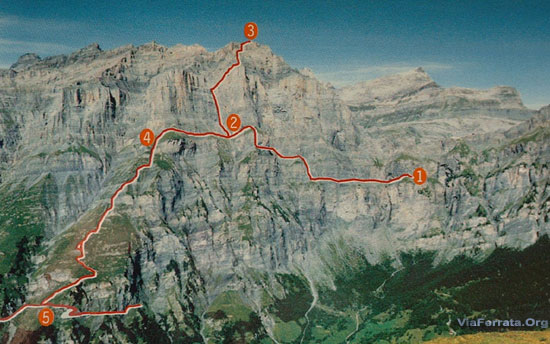
502e Via Ferrata Rocher Jaune, Les Diablerets, Vaud, Switzerland
Via Ferrata Rocher Jaune / Tête au Chamois, Les Diablerets, Vaud
Footbridge Wood Bridge Ladder Zipline 0 1 x 3m 0 0 Features
Established during the International Alpine Film Festival on the 10th of October 1999, this via ferrata is also known by the name of "Tête au Chamois." It is located next to the first stop of the telecabine.
Setting: Splendid high mountain, a precipitious itinerary that offers a wide variety of terrain, alternating between comfortable sections on fairly wide ledges and impressive sections on slabs resembling climbing
Via Ferrata Tips
You have to pay for the cable car.
For the brave: from the village its 3h50 of walking there and back. Or buy only the way there and you can enjoy the way down... The Diablerets is an ideal region for canyoneering and mountain biking.
You are in a high mountain setting: Don't forget to take an extra layer and a jacket. Temperatures, even in the summer, can be cold. Excellent hiking shoes are necessary. The ground is often wet and slippery.Legend has it that the people of this region are very attached to their money. So if a coin falls from your pocket and does not land on the ground, remember this!
Grade
Strength 4 Dizziness 4 Type High Mountain: 2 Technics 1 Evaluation Very Difficult
Information
Tourism Office des Diablerets 024 492.33.58. +41.24 492.33.58
Cabane des Diablerets
Length
Length: 800 m
Orientation: North (in the shade)Start: 2'400m.
Finish: 2'450mGPS Coordinates of the Starting Point
N 46’20.357
E 007’12.854
Altitude : 2’426 mTime of Year
June-October
Timing
Approach from the cable car: 5 min.
Via ferrata 2h30,
Way back to the cable car : 15 minutes
Way back by foot, 1h30 2h00.By Car
From Lausanne take the highway towards Valais (Martigny, Sion) and exit in Aigle.
In the middle of Aigle, at a roundabout on the left take the route du Pillon towards Les Diablrets, it is indicated.
From Valais, Chamonix or the Aosta valley, take the Martigny highway towards Monthey-Lausanne. Exit at Aigle.
By Train
Contact the SBB, for bus and train schedules and fares. Take the train to Aigle, the small train to Diablerets, then the bus for le Pillon
Access
Leave your car in the parking lot located at the base of the Diablerets glacier ski lifts.
By foot:
Several footpaths lead to the base of the glacier's cablecar, here is the shortest, but account for 1h40 of walking. From Corabs, take the Aigue-Noire trail, then the Cascade du Dar and Col du Pillon.By cablecar:
Otherwise you can take the cablecar and the ferrata is located at the first stop, this is a faster, but more expensive option.From the hut, take the trail that goes down on the right (follow the blue and white markings)
Via Ferrata
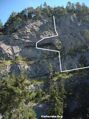
The Ferrata follows a vertiginous ledge that is more or les pronounced, sometimes interrupted for some meters, requiring traverses, descents or climbs up rungs or small steps. The surroundings are vertiginous.
You will go through a mini cave and the famous section with a small wooden beam. If you are lucky enough to be over 190cm tall: may the force be with you!
The end of the via takes place on a fairly demanding wall that climbs straight up and is well equipped but always has certain points of contact with the rock. This wall brings you to the end of the via.
Way Back
If you are on time, you will be able to take the cable car. If you are beat, stay at the hut.
Where to Spend the Night
You can find a camping and some nice rooms in guest houses in the Diablerets.
Diablerets Hut: 60 spots available 024/492 21 02. For 25.— Frs., you'll have a bed!Photos
-
503e Via Ferrata Tiere Champery Valais Switzerland
Via Ferrata of Tière, Champery, Valais
Footbridges Monkey Bridge Ladder Zipline 2 0 0 0 Features
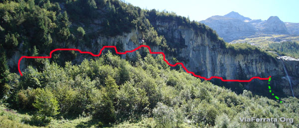
Begins with some beautiful footbridges which are quite chilly due to the proximity of the waterfall. Traversing for the most part. One section can slow down beginners, it is a bit athletic and relies on the arms for 3-4 meters.
ViaFerrata Tips and Tricks
Leave a shuttle car at the beginning of the ferrata. The trail to get back to the village is a bit long... If you have a mountain bike, it will do, especially as the region is perfectly suited for mountain biking.
If you decide to do everything on foot, go by way of the Galeries Défago (a trail carved into a cliffside). It is next to the via and it is a beautiful hike on a vertiginous cliff, but accessible for everyone.It is a bit hot during the summer in the afternoon. Better to do it in the morning when it is still in the shade.
Grade
Strength Partie 1: 1
Partie 2: 2Dizziness Partie 1: 1
Partie 2: 2Type Mountain
Partie 1: 2
Partie 2: 1Technics 2 Evaluation Partie 1: Beginner
Partie 2: Difficult (1 difficult step 3-4 m)Information
Office du Tourisme de Champéry
Length
Length 460 m.
Elevation gain 125 m.
Altitude at the start of the via Ferrata 1'126 m.GPS Coordinates
N 46'10.630
E 006'53.013Time of Year
May - October
Timing
Approach: about 30 minutes from the Centre Sportif (in the village). 10 minutes from the start
Via Ferrata: 30-45 minutes
Way Back: 45-60 minutes to get back to the Centre SportifBy Car
Geneva-Lausanne, take the highway towards Martigny-Sion-St-Bernard. Exit at St-Triphon/Monthey.
Take the tunnel that goes up the valley towards Champéry-Morgins.
At Troistorrents take the road towards Champéry.By Train
Take the train to Aigle. Then the AOMC towards Champéry. The train terminal is found a stone's throw away from the trail that leads to the via ferrata. Contacte the SBB for bus and train schedules and fares.
Access
Option 1
Go towards the tennis courts that are found near the train and cable car station. At the tennis courts and in front of the Paladium (huge sports center), go down the Chemin duTavis trail and the bridge of the Sous-Sex which goes towards the river. Leave your car near the little wooden bridge. Cross the bridge by foot and you will see a sign on the left which indicates the trail that climbs through the woods and leads to the via ferrata.Option 2
By car, go towards the Grand-Paradis. Just before arriving to the Grand paradis, 200m after the stone bridge that you pass by car, go left just before the little bridge that straddles the river.Do not cross the river, but go along it. Take the road that goes left and follow it. Once you arrive at a junction that is found near a tiny bridge straddling a small river, you are there. The trail that leads to the start of the via is found 8 meters after the bridge, in the direction towards Grand Paradis. It goes down rather steeply on the right.
Via Ferrata
The via starts with a footbridge and a kind of small hike to work up your appetite. A second footbridge, this time via ferrata style.... and a small uphill to whet your adventurous spirit and arrive at the very beautiful and impressive large footbridge 10 meters above the waterfall.
You'll get a little rest along a ledge before seeing the Bear... if you pay attention... he is hidden in a small cave! Whoever doesn't see him pays the next round!
Next, the serious part begins. A very demanding 4m section can prove to be an insurmountable obstacle for beginners, but once it is overcome, it is amazing. One even regrets that the ferrata finishes so quickly, as it is so enjoyable.
Way Back
See above.
Where to Spend the Night
Camping in Champéry, in the area called the Grand Paradis.
{youtube}ri9valGZ5Ag|500|330|0{/youtube}
par ViaFerrata.com Youtube
Photos
-
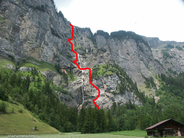
504e Via Ferrata de la Cascade Les Diablerets Vaud Switzerland
Via Ferrata de la Cascade, Les Diablerets, Vaud
Footbridges Monkey Bridge Ladder Zipline 2 0 0 1 Features
Very committing with a splendid section under the waterfall and in a crack.
The steps for your feet are very slippery as they are made from smooth metal. Be careful during wet periods, the steps turn into bars of soap!
No elevation gain or drop, completely a traverse.
ViaFerrata Tips and Tricks
Take your camera, the view from behind the waterfall is magnificent and like nothing you've ever seen before.
Wear some good shoes with a rigid sole and traction control if possible.
Zipline
We don't want to start a dispute, but a zipline shoud have a cable and a life-line (the cable that secures you). On this zipline, there is only one cable and the pully is already on the cable (it stays there all season). Personally, we have given up on using this equipment and the the zipline and have opted for the second way out. But the choice is up to you...Tips and Tricks for Zipline Users (by Franck Lehmans)
-Have a tall or self-sufficient person go first so that he/she can untie him/herself easily and without risk at the end of the zipline
-Once at the end, grab the cable so as not to go backwards
-Clip one landyard in a loop of the cable so as not to slide backwards
-Next, and only next, untie (or try to untie (if you are too small, it's really SH...)) the pulley!
-While you pull the rope that brings the pulley back to you, let it hang in the void to prevent any potential knots from forming on the way and creating a very annoying obstruction in the middle of the cable.- Do not tire yourself in vain trying to unclip the pulley from your harness: think and proceed in the following order:
1 first landyard hooked in a loop of the cable when you arrive,
2 second landyard hooked even further if possible,
3 lift yourself up as much as possible (I put myself on the big bolts that hold together the pole at the finish),
4 unclip yourself.If you can't do it, re-secure yourself like on the way there and climb back to the start by pulling yourself with the rope.
Grade
Strength Part 1: 4
Part 2: 3Dizziness part 1: 1
Part 2: 3Type Mountain: 3 (slipery steps) Technics 1 (zipline optional) Evaluation Extr. Difficult Information
Office du Tourisme des Diablerets 024 492.33.58.
From outside Switzerland ++41.24 492.33.58
E-mails work really well, fast and nice.Length and Altitude
Altitude: 1491 m
GPS Coordinates
N 46’20.998
E 007’12.157Time of Year
May - November (when there isn't any snow or ice).
Timing
Approach : 20 minutes
Via Ferrata : 1h30
Way Back : 25 minutes
By Car
From Lausanne take the highway towards Valais (Martigny, Sion), and exit at Aigle. IN the center of Aigle, take a roundabout and on the left la route de Pillon towards Les Diablerets, it is indicated.
From Valais, Chamonix, or the Aosta valley take the Martigny freeway towards Monthey-Lausanne. Exit at Aigle.
By Train
Take the train to Aigle and then to Diablerets. A bus towards the col du Pillon will take you the rest of the way. Contact the SBB, for bus and train schedules and fares.
Access
Leave your car in a mini parking 200m before arriving at the Col du Pillon (on your right when coming from les Diablerets)
The trail that leads to the via ferrata starts near this parking. Follow the signs.Via Ferrata
The beginning is very hard. There is an overhang and a rope bridge, but beware, this rope bridge is reserved for real monkeys only! It's not easy to access and it really works the arms.
After the bridge, your arms are still put to work with some tough overhanging sections. Plus, since the steps are made with smooth metal, you get the impression that you are walking on banana peels! After this section, you climb to a grass and earth section.
You can avoid this demanding first part by taking the easier via ferrata which was set up in order to go around this particularly athletic section.The second part is a bit more technical and vertiginous. You have the opportunity to touch the rock and make sure you pay attention to where you are placing your well-equipped-with-good-vibram-soled-shoes feet. But, of course, you already know that one only climbs via ferrats with the proper shoes!
In short, it's strenuous, it doesn't climb too much and it's often overhanging.
As you approach the waterfall, you will cross a superb crack in the rock. Hmmmm, it is very narrow and one barely makes it through with a backpack.
So, if you have a little extra padding, you'll have to suck in your stomach. But, it's really awesome!
You then arrive in front of the waterfall, and here is the second exit.You can go behind the waterfall and take the zipline.
Way Back
If you exit before the waterfall: the way down is super slippery!
If you exit after the waterfall: the way down is super slippery!Where to Spend the Night
There is a camping and some nice rooms in guest houses in les Diablerets.
Media
par Boris Bettex, Youtube
-
505e Via Ferrata Tour d'Ai, Leysin, Vaud, Switzerland
Via Ferrata Tour d'Aï, Leysin, Vaud
Footbridges Monkey Bridge Ladder Zipline 2 0 0 0 Features
Vertiginous with a superb panorama on Lake Geneva, the Valais Alps, and Mt-Blanc. A bit difficult for children and beginners.
Some steps are a bit high/too far for people of average height.
ViaFerrata Tips and Tricks
Take your mountain bike (MTB) with you or rent one there, for the way down to Leysin is very nice.
A picnic is a must. At the summit of the via ferrata you can enjoy the incredible panorama while you eat.
Parking. We already received some messages from the Tourism Office and some inhabitants of Leysin lamenting our rant about the fact that there are no free parking spaces for the users of the via ferrata.
Consequently, we are making an effort to commend this great initiative to welcome tourists to the station with a fine if they do not pay for their parking and we really think its super cool and nice that they put a free parking lot 4km away from there. It would have been totally stupid for them to offer a combined lift and parking ticket for the users of the via ferrata as we suggested.Grade
Strength 2 Dizziness 2 Type High-Mountain: 1 Technics 1 Evaluation Difficule Information
Office du Tourisme de Leysin
Lifts: Télé-Leysin.
Length and Altitude
Lenght 320 m.
Elevation Gain: 150 m.
Time of Year
End of May to mid-October. Check with the lifts for the official start of the season.
Not practicable in the winter.Timing
Approach from the top of the lift: 45 minutes
Via Ferrata 1h00 à 1h30
Way down to the mountain pasture: 45 minutes
To the parking lot: 30 minutes with an MTB, and 1h30 by foot.By Car
From Geneva, take the highway towards Lausanne and then Sion-Martigny. From Chamonix and Aosta take the highway towards Martigny-Suisse. In Martigny take the highway towards Lausanne-Geneva. Exit at Aigle (25km).
In Aigle take the N 11, towards Château d'Oex, les Diablerets, Leysin.
By Train
Prends le train jusqu'à Aigle et ensuite jusqu'à Leysin.
Take the train to Aigle and then to Leysin.
Contact the SBB, for train and bus schedules and fares.Access
Take the Berneuse lift.
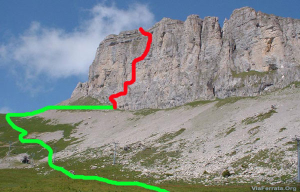
There are few indications and markings, so you must have faith. When you arrive at the summit of the lifts you will see the Kuklos rotating restaurant. Look towards the restaurant. A mountain with a cliff rises in the background to its right. This is where you will find the Tour D'Aï ferrata.
Go down the very steep trail that leads to some small houses and a charming lake. Once you are at the bottom, climb up the hill on the left following the cables and poles of the lift. You will find a little trail that will lead you to the start. (see the picture from the guide at the top of the page).
Via Ferrata
There are some difficult moves from the very beginning. If you get pass them... you should be fine for the rest. Otherwise, turn back now gringo!
A little traverse up and down... brings you to the foot of the chimney. You will have to get past it... it's a nice opportunity to play Santa Claus. We hope that after this you will realize how hard Santa really works and that this coming winter you will leave him some cookies by the chimney...
It's a bit overhanging at the end of the chimney, but only a bit, and you get to see the void all around you. You arrive tranquilly to the summit of this via. Just one more little section, great for photos. The summit of the via is almost a classic.Once you arrive on the plateau, you can make the most of an unforgettable and splendid panorama.
Way Back
The way down is a bit athletic, around 40 minutes. Be careful, there have already been deaths.
Once you arrive at the lake, you can get your bikes (if you came with your MTBs)... and off you go, down either to Leysin or Aigle.
If you came by foot, the concept is the same, but the way down to Leysin is a bit longer.
Where to Spend the Night
Camping Semiramis: Tel: +41 24 494 11 48 .
Media
vidéo par ViaFerrata.com, Youtube
-
506e Via Ferrata Videmanette Initiation Rougemont Vaud Switzerland
Via Ferrata Videmanette, Rougemont, Vaud
Footbridge Monkey Bridge Ladder Zipline 0 0 0 0 Features
This is an introduction to Via Ferratas for beginners and children and if the first part is okay, there is a second part that is a tad more demanding.
ViaFerrata Tips and Tricks
Take your MTB for the way down to Rougemont. A bit steep at the beginning, but very nice in the end.
Grade
Strength Via 1: 1Via 2: 2Dizziness Via 1: 1
Via 2: 2Type High-Mountain
Via 1: 3
Via 2: 2Technics 1 Evaluation Via 1: Initiation
Via 2: Difficult
Information
Tourism Office: Rougemont-Château d'Oex
Length and Altitude
500 m et 200 m (2 parts),
Start at 2'130 m
Finish at 2'284 mGPS Coordinates
N.46'27.666
E 007 12.444Time of Year
When the lifts are open. (usually June to September).
Timing
Approach from the top of the lifts 3 min.
ViaFerrata: 15-20 minutes
Way back: 15 minutesBy Car
Highway Geneva-Lausanne: exit at Aigle-> towards Château-d'Oex.
From Fribourg: exit the highway at Bulle, towards Château-d'Oex.Once you are in Château-d'Oex go towards Gstaad, Saanen. Once you are in Rougemont, go right at the roundabout and go down towards the river where there are some lifts.
By Train
The train leaves from Montreux and stops in Rougemont. Contact the SBB, for schedules and fares.
Access
Take the lifts to the top of the Videmanette, here is the start of the via,
For the super athletic, it is possible to walk up from Rougemont. Good luck!Via Ferrata
There are no major difficulties except for a small part that is a little strenuous and an ity-bity vertiginous section.
Excellent for beginners and for those who love walking. The ferrata is divided into two parts. On the way up, take the path on the left which is more like a ferrata. The path on the right is mostly used for the way down, and presents no difficulties. There is a beautiful panorama at the summit.
It is possible to dine at the restaurant.
Way Back
Take the path that leads to the restaurant and the top of the lifts.
Where to Spend the Night
Camping with a pool in Chateau d'Oex.
Media
-
507e Via Ferratta Videmanette 3 Rougemont Vaud Switzerland
Via Ferrata Videmanette 3: Sportive Rougemont
Footbridge Monkey Bridge Ladder Zipline 0 0 1 0 Features
Extremely vertiginous with some technical sections.
Holds directly on the rock, big distances between the fixed points of the lifeline.
Enough vertigo to last you a lifetime!
ViaFerrata Tips and Tricks
Take your MTB for the way down to Rougemont. It's a bit steep at the beginning, but very nice in the end.
Don't go alone, this one is quite impressive. The void is ever present!
Grade
Strength 4 Dizziness 4 Type High Mountain: 2 Technics 2 Evaluation Very Difficult Information
Office Tourisme Rougemont-Château d'Oex
Lifts: remontées mécaniques de la Videmanette
Length and Altitude
Start 2'100 m
Finish 2'284 m
Length: 400 mGPS Coordinates
N.46'27.666
E 007 12.444Time of Year
When the lifts are open. (June to September usually).
Careful, the operating times of the lifts change depending on what day of the week it is.Timing
Approach from the top of the lifts: 3 min.
Via Ferrata : 45 minutes
Way back: 15 minutesBy Car
Highway Geneva-Lausanne: exit at Aigle-> towards Château-d'Oex.
From Fribourg: exit the highway at Bulle, towards Château-d'Oex.Once you are in Château-d'Oex go towards Gstaad, Saanen. Once you are in Rougemont, go right at the roundabout and go down towards the river where there are some lifts.
By Train
The train leaves from Montreux and stops in Rougemont. Contact the SBB, for schedules and fares.
Access
Take the lifts to the top of the Videmanette, here is the start of the via,
For the super athletic, it is possible to walk up from Rougemont. Good luck!20 meters before the start of the other via ferratas, go left into the talus that is on the same side as the lifts. You should see the ladder that starts the via. The way down is a bit difficult, be careful...
The presence of the void is sensational.
Via Ferrata
It starts off really hard with a chimney where you have to place your feet on either side of the walls. At the top, you will have to think a bit to figure out how to get out. Void with a big V.
One wonders how Santa Claus can manage this!!! I'll attempt to describe the situation for you... you have three steps... and then nothing at all. The void seems to exaggerate his presence here.
If you have trouble with this first part, turn back. The rest is even more difficult, and what's more, up above with the void, it's a whole other story.
You then continue with a nice traverse...and there... there, there... like us you will have a hard time finding words. This last part starts immediately with a huge sensation of void. There are more than 200m under your little feet! The steps are quite far from each other, as are the cable's fixed points. Once you arrive to the ladder of the void, you'll be greeted by an overhang that will use up what's left of your arms.
Next, you exit the via, through a fairly tricky section. Make sure you don't kick any rocks onto the heads of your friends climbing beneath you.
At the summit, you find the easy sections of the other via ferrats.
Way Back
Take the path that leads to the restaurant and the top of the lifts.
Where to Spend the Night
Camping with a pool in Chateau d'Oex.
Media
-
508e Via Ferrata de Talli, Meiringen, Bern, Switzerland
Via Ferrata Tälli, Meiringen, Bern
Footbridge Monkey Bridge Ladders Zipline 0 0 5 0 Features
Takes two days, the approach is a bit long, but of mid-range difficulty. The via has several vertiginous sections.
ViaFerrata Tips and Tricks
Take the map of the area and all the gear you need to spend two long days in the mountains.
Only go if the weather is good and stable because there are no way outs. At the beginning of the summer snowfields remain at the start, on the ledges at higher altitudes and on the return path of the north face (equip yourself with crampons and an ice-axe if needed- but you must know how to use them).
Reserve a place at the hut before leaving.
Grade
Strength 4 Dizziness 4 Type High-Mountain: 2 Technics 2 Evaluation Very Difficult Information
Length and Altitude
1'500 m elevation gain, 600 m of which is the ferrata
Start of the via: 2'067 m
Time of Year
July to early October
Timing
1st day: 550 m of elevation gain: 2h00 of walking
2nd day: 1'000 m of elevation gain, 600 m of which is the via. This should total to 6 h.By Car
Lyon-Geneva, A 40; Geneva-Lausanne N1, in Vevey go towards Bern, Basel/Bâle N12;
->In Bern, take N6 towards Interlaken,
-> in Interlaken go towards Méringen-Furen.By Train
By bus from Meiringen to Gadmen. Contact the SBB for schedules and fares.
Access
From Furen (1149m) on the road from the bottom station of the Tälli lifts (1171 m) to the Tälli restaurant; there is no official bus stop.
Information from the electric power plant in Innertkirchen, tel. 033 982 20 60.
On foot, briefly follow the trail to access the Birchlaui pasture (1,597m) by going up the sparsly forested slope to the Tälli restaurant (1,716m). Take the sidelong uphill by following the white and blue markings under the steep walls of the Tällistock until you reach the start of the Alpligerstock via (2,067m).
Via Ferrata
The ferrata starts with a very steep ladder that leads to a flat vertiginous ledge. Follow it towards the right until the security equipment indicates a new ascent.
The via ferrata gains more and more altitude with some steps in the rock, grassy overhangs, and narrow ledges; there is a welcoming bench one third of the way up the via ferrata.
Follow a fairly exposed traverse before taking the path that leads to a kind of terace ledge on the upper part of the rock wall. Three staggered vertical ladders allow you to easily climb an abrupt dihedral. Stay focused when you go from one ladder to the next...your heart will skip a beat!
Another metallic ladder leads sideways to an ascending grassy ledge. To finish, we climb the ridge via a landslide to the exit.
Sign the golden book that is found in the cave.
Way Back
Follow the white and blue markings to a rocky cirque (snowfields often remain here at the beginning of summer). Be careful as some of the steeper snowfields can be icy.
It will take a good hour, then, take a more or less flat path heading SW for another good hour, which includes the way back up towards the Satteli pass (2119m).
Lastly go back down towards the Tallihutte in about 45 min.Where to Sleep
Refuge de Tällihutte, 20 spots available, open from mid-June to end of October.
Account for about 20.-- Frs. per person, Tel. 033 975 14 10. If calling from outside of Switzerland ++ 41 33 975 14 10
Media
by Hans Howald, Youtube -
509e Via Ferrata Diavolo, Andermatt, Uri, Switzerland
Via Ferrata Diavolo, Andermatt, Uri
Footbridge Monkey Bridge Ladders Zipline 0 0 2 0 Features
For beginners or children, even if, as the Little Prince said in a whisper, many adults are still kids at heart...
The whole route overlooks the famous Devil's Bridge.A truly spectacular itinerary through the granite of the Schöllenen, interspersed with grassy sections.
ViaFerrata Tips and Tricks
Warning: the route is equipped with 265 stakes/pitons and not metal steps. This can be dangerous in wet conditions.
Account for half a day to complete this via ferrata, and then zoom in your car, past the Susten pass and to the Tälli refuge (it is not very far). That way in the afternoon you'll be able to do the Talli ferrata and so pass from granite to limestone...my what a grand idea for a week-end that is... This option is only for those who have strength and are in good physical condition.
Because of the stakes/pitons that are used instead of the traditional steps, make sure you take good hiking shoes.
Grade
Strength 1 Dizziness 2 Type High-Mountain: 3 Technics 2 Evaluation Beginner Information
Office du Tourisme d'Andermatt.
Length and Altitude
Start: 1'410 m
Finish: 1'860 mElevation Gain: 450 m
GPS Coordinates
Time of Year
Mid-June to October
Timing
Approach: 10 minutes
Ferrata: 1h30
Way back: 45 minutesBy Car
1km before Andermatt at the Devil's bridge site.
You can get there by leaving the Lucerne-Lugano highway just before the north entrance of the Gothard tunnel (Göschnen exit) and by taking the pass road (highway exit- devil's bridge = about 8km).
By Train
Take the Furka-Oberalp train from Göschenen to Andermatt. 20 short minutes by foot, and there you go, you already feel the via ferrata air (Devil's Bridge)
Contact the SBB, for train schedules and fares.Access
From the Andermatt station via the main road (there is a sign) by l'Urner Loch to the Schöllenen gorge.
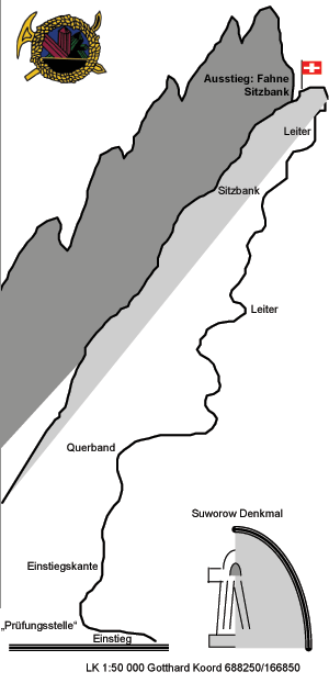
The start of the via is near the devil's bridge bistro next to the monument in the memory of Souvarov's army (50 meters on foot from the road and the parking!)
Via Ferrata
The via ferrata takes place in this magic all granite setting, with some grassy sections that are steep and slippery at times if the conditions are wet.
The cable covers the entire length of the route. There are some bars, quite a lot of pitons, and 2 ladders. And for your pleasure there are no "muscle-man" sections.
2/3 of the way is a little bench where you can take a break. The view is especially worthwhile... The setting is absolutely splendid, a river winds its way through a gorge against the backdrop of high alpine summits.
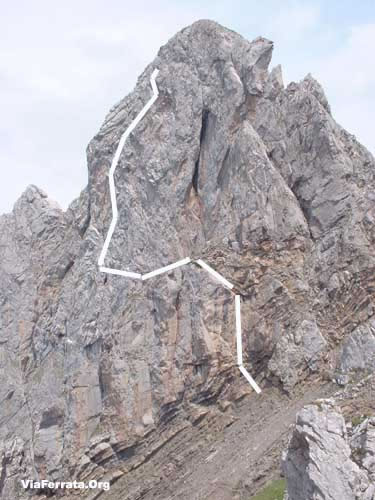
A long un-secured traverse leads to the final section of the itinerary (gold book): a couloir, a rocky exposed angle and to finish a vertical ladder, and then we arrive on the edge of the Tüfelstalboden (env. 1860m). Just a bit higher is the welcome air of a nice break under the Uri flag with a view on the granite peaks of the Salbitschijen.
Way Back
From the end of the via ferrata, the path is well marked (white/red/white markings) to go back down to Andermatt, and then go along the road to get back to the car, all of this (the way down) takes about 45 minutes.
Where to Spend the Night
Since authorities have let a big eyesore in the form of the oversized (but empty) Palace be built, it is difficult to find affordable accomodations in this area.
We tried out the Youth Hostel 5km from Andermatt: Walchwilerhus, Gotthardstrasse, 6493 Hospental. It doesn't look like much from the outside, but it's really nice inside and the staff was really friendly.
Tel. +41 (0)41 759 80 10Media
par uster727, Youtube -
510e Via Ferrata Baltschiedertal, Baltschieder, Valais, Switzerland
Via Ferrata de Baltschiedertaler, Baltschieder, Valais
Passerelle Pont de singe Echelle Tyrolienne 1 0 0 0 Features
Located in a magnificent area. The view and the setting are very beautiful. But you will need the better part of a day to complete it.
It's long, in the style of Dolomite via ferratas.ViaFerrata Tips and Tricks
You are in a high mountain setting, be wary of changes in the weather.
Take warm clothes and enough chocolate to keep you going. Avoid going if it just rained or if the conditions are wet. There are a lot of slippery parts and they are not always secured.
Grade
Physique 4 Gaz 3 Type Haute montagne: 3 Technique 3 Evaluation Très Difficile Information
Wiwannihütte, the hut that maintains the via ferrata.
Length and Altitude
Start: 2'027 m
Finish: 2'444 m
Elevation Gain: 910 m
Via Ferrata Length: 2'100 mGPS Coordinates
Time of Year
June-October
Timing
Via Ferrata approach: 2h30 – 3h
Via Ferrata: 3-4 heures
Way back: 2h30By Car
Cross the entire Valais towards Brig.
After the town of Rarogne (Raron in German) and near Viège/Visp, follow directions for Baltschieder (Baltschiedertal).
By Train
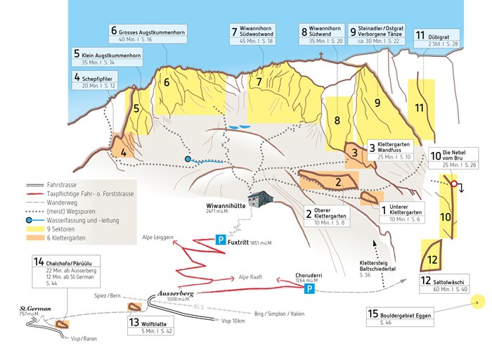
You can get there from Sion or from the canton of Bern via the Lotschberg. Contact the SBB, for schedules and fares. The cursor indicates the Wiwanni Hut.
Access
Well, I'm going to start with a rant: you have to pay for parking!!! and it's really expensive. Have a minimum of 6 to 7.— Frs. for your place at the via. And a lot more if you're planning on sleeping at the hut!
Back to the subject. The said parking is found across from to the Sonnehalde Restaurant.
But if you don't like to walk, continue on the toll road towards Nirwarch (account for 10.-- Frs.) and drive until you get to the first hairpin. There is a parking nearby.
Otherwise you can leave your car at the bottom and walk this section. This takes about 30 minutes.
From there, follow the path towards the Baltschieder Hut (follow the red and white markings). A nice stream accompanies you until the path gets steeper. Be careful this trail is vertiginous when it is narrow.
After a good climb, you will find a white/blue marked trail on the left. This is the trail for the via ferrata.
Via Ferrata
The Via Ferrata starts with a steep section and then goes into a crack. The slope is not very steep and you are in contact with the rock. It's nice.
Next comes a little ordeal. An interminable path in the grass, mud, and rocks. He who is forewarned is forearmed, so don't have a panic attack!
The cable is interrupted by a section that is a bit risky and then you get to the second part of the via ferrata. There, you will go along a big boulder that overlooks the gorges. The landscape is incredible!
The via ferrata ends along a rocky ridge.
Way Back
It takes about 30 minutes to get to the hut when following the blue/white trail.
Where to Spend the Night
Wiwannihütte 027 923 09 03 next to the 3001m Wiwannihorn.
Two hotels in the area:
Hotel Bahnhof 027 946 22 59
Hotel Sonnenhalde 027 946 25 83.
Media
-
511e Via Ferrata Jägihorn, Saas Fee, Valais, Switzerland
Via Ferrata de Jägihorn, Saas Fee in Valais
Footbridges Monkey Bridge Ladders Zipline 0 0 5 0 Features
Starts from a hut at 2,726m... 5 ladders with 400 rungs...
ViaFerrata Tips and Tricks
This is a veritable alpine route where you will climb all the way to 3,206m. Take the necessary clothes and equipment.
This ferrata is very long. You had better be feeling your best and in excellent shape to complete it.Grade
Strength 4 Dizziness 3 Type High Mountain: 2 Technics 2 Evaluation Very Difficult Information
Saas Fee Tourism Office
Length and Altitude
More than 1'000 m. of cable.
Start of the Via Ferrata: 2'820 m.
End of the ViaFerrata: 3'206 m.GPS Coordinates
Time of Year
End of June to September.
Timing
Approach: 1h15
ViaFerrata: 3h00
Way back: 1h30
It takes 5-7 hours to complete the whole thing!!!By Car
Valais highway towards Brig. From Brig go towards Saas Fee- Zermatt. It takes about an hour from Sion.
By Train
There is a train to this destination. Contact the SBB, for train schedules and fares.
Access
Take the Saas-Grund-Kreuzboden 2400 lift. Then for the approach you'll walk a good hour and 15 minutes.
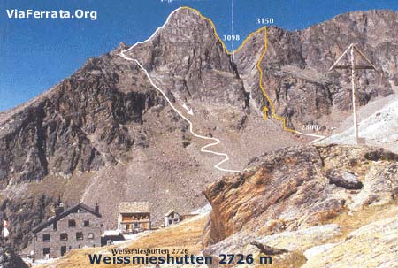
From the Kreuzboden station (2,397m) towards the Weissmies huts. A sign points to the via ferrata. Take the marked trail passing on the Triftbach, then climb the steep crest of the moraine until you get to the long flat traverse to the start of the via ferrata (about 2820m).
Via Ferrata
You go around a rocky projection on the left thanks to a life-line, then you climb on some steps in a characteristic couloir.
From there, it gets steeper and steeper. There are some hooks where holds are lacking. Be careful not to provoke any rock falls!
The rough and abrupt climb of the rock is stimulating, it is a bit vertiginous to the first ladder.
A series of ladders higher up the wall. It's fairly strenuous. You get to the final rungs via a steep slope, juste below the secondary summit (3150m).
To the left after a ledge is a secured almost continuous downclimb (a ladder) and it is partially vertiginous along the west ridge until the gap (3096 m) in front of the Jägihorn.
Go to the left of the sharp ridge (very original) to the starting point of the ascent towards the proper summit. At the rocky block, the climb is at first easy and then gets more and more steep and vertiginous. Now comes a particularly original abrupt section where the crampons are placed directly over the ridge.
To finish a flatter part leads to the wide summit.
Way Back
It takes about 30 minutes to get to the Weissmies Refuge by following the blue/white trail in the west face of the mountain that descends to a steep rocky couloir.
Be careful, it's vertiginous. The way down zig-zags and leads to the small valley via an abrupt pile of fallen rocks. Here you can choose to go towards the Weissmies hut or go directly towards the valley to the Kreuzboden station.
Where to Sleep
Weissmies Refuge: +41 (0)27 957 25 54
Vidéo par OutdoorRolf
Photos
-
512e Via Ferrata Tichodrome Noiraigue, Val de Travers, Neuchatel, Switzerland
Via Ferrata Tichodrome Noiraigue, Val de Travers, Neuchâtel
Footbridge Monkey Bridge Ladder Zipline 0 0 0 0 Features
Discover the Val-de-Travers from another perspective. Excellent vertiginous sensations.
It is closed annually from the 1st of January to the 1st of July so as to allow Peregrin Falcons, Kestrels, and Wallcreepers to nest in peace.The entry and exit cables are removed each season, thus blocking access to the cliff.
ViaFerrata Tips and Tricks
This via is great for first timers and kids 10 or older, take your quickdraws as it is not equipped properly for you to secure your kids with a rope.
This area is rather humid. Good Vibram soles and hiking shoes are necessary. There is an antenna, go have a look at it to see the Neuchâtel lake.
A question for the champs: Why is it called Tichodrome?
This is the French name for the bird that nests in these cliffs (Wallcreeper in English).Grade
Strength 1 Dizziness 2 Type Plain: 2 Technics 1 Evaluation Beginner. Easy Information
Tourisme Neuchâtelois Val-de-Travers.
Association: « Via ferrata et escalade sportive »
Centre sportif du Val-de-Travers: www.centresportif-vdt.chLength and Altitude
Cable length : 550 meters, no exit possible
Elevation gain : 150 meters
Start elevation: 950m
End elevation: 1150mTime of Year
Open from the 1st of July to the 31st of December (due to the bird nesting regulations, the entry cables to the route are removed outside of these dates).
Timing
Approach: 5 min
ViaFerrata: 1h00
Way Back: 5 minBy Car
From Neuchâtel go towards Val-de-Travers, Peseux, Rochefort, Noiraigue, at the exit of the Clusette tunnel, go towards Ponts-de-Martel and you are there. Haut de la Côte parking.
From Chaux-de-Fonds, go towards Val-de-Travers, la Sagne, Brot-Dessus. Haut de la Côte parking.By Train
Neuchâtel-Noiraigue (then on foot to the via, about 1h00)
Chaux-de-Fonds-Les Ponts-de-Martel (then on foot to the via 45 min.-1h00). Contact the SBB, for schedules and fares.Access
On foot, you can get to the beginning of the Via Ferrata from the Ponts-de-Martel station (45 minutes), from the Noiraigue station (1 hour), or from the Haut de la Côte restaurant (10 minutes).
From the parking, go briefly along the ridge on a marked trail and then head right towards the asphalt road lower down. Cross this road and go through the forest until you get to the start.
Via Ferrata
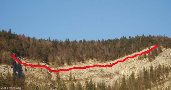
A nice ledge above Noiraigue.
Michel Gentil and his association, "Via Ferrata et escalade sportive" dug into this rock over time to make a very enjoyable via ferrata out of this ledge. The equipment and information he used were very carefully chosen. There is only one section that could make those who are less brave shudder, an overhanging section.
Magnificent view on the Neuchâtel lake at the top of the via.
You start by crossing a rocky projection on the way up by passing on natural ledges. Easy sections alternate with vertiginous sections where the cable is not completely taught and you hang out over the void. A good dose of void stretches out below your feet at the Nest Overhang. The itinerary splits before the view point (1,119 m), but this view is absolutely worth the detour.
Way Back
You can either go left along the ridge on the higher altitude Jura trail towards the start (and return to the train station) or you can go on the forested ridge that overlooks the restaurant parking. It is well indicated.
Where to Spend the Night
All the information for where to spend the night, to eat, to go on beautiful hikes, or to discover the Val-de-Travers region, its museums and its particularities, is available from the Neuchâtel Val-De-Travers Tourism.
Vidéo par AandG2009, YoutubeMedia
-
513e Via Ferrata d'Evolène, Evolène, Valais, Switzerland
Via Ferrata d'Evolene, Evolène in Valais
Footbridge Monkey Bridge Ladder Zipline 0 0 1 0 Features
In 3 parts...and none are insignificant...
1 ladder, 3 overhanging sections that work the arms, beautiful view on Evolène. And vertiginous!
Not for everyone. Only for those who have already done via ferratas before.ViaFerrata Tips and Tricks
If you do this one at sunset... you will enjoy a view that is absolutely magnificent. There are three parts and an escape route exists between the three parts.
Bring your camera, the view of the village is very beautiful
Grade
Strength Partie 1: 3
Partie 2: 1
Partie 3: 4Dizziness Partie 1: 3
Partie 2: 2
Partie 3: 4Type Mountain: 1 Technics 2 Evaluation Extreme Information
Office du Tourisme d'Evolène.
Length and Altitude
Length: 700 m
Elevation gain: 400 m
Altitude: 1'497 mGPS Coordinates
N 46’06.460
E 007’30.242Time of Year
From spring to autumn.
Timing
Approach: 5 minutes
Via Ferrata
Part 1: 15-20 minutes
Part 2: 5-10 minutes
Part 3: 25 minutesWay back: 15 minutes
By Car
Rendez-vous in Valais. From Geneva take the highway towards Lausanne-Sion. From Chamonix and Aoste go towards Martigny and then take the highway towards Sion.
In Sion, take the second exit (hospital). Go off to your left and at the last roundabout where the Tamoil Gas Station is, go towards Vex, Val d'Hérens. Evolène is found up there. On the road you'll see the Euseigne pyramids. It's beautiful!
By Train
Go to Sion and then take the bus from the Sion train station.
Contact the SBB for train fares and schedules.
Access
Don't go into the village of Evolène, stay on the road that goes to Arolla.
200m after the Coop store, you'll find a little parking lot on your left. That's when you'll give your wheels a break and put your muscles to work.
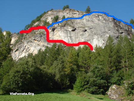
Go up towards the forest (mountainside) to find your way to the base of the cliff. Everything is marked.To get to the beginning of the "easy" part of the "Chamois Ledge", take the path that goes up on the right.
Via Ferrata
Your journey starts with an overhang that, on top of taking your breath away, drains your arms of strength! The first overhang is followed by a second that is no less tricky. For your humble servant, who is taller than most, it was all rock & roll.
If you get past this first obstacle, you should be fine for the rest. Otherwise, the goose is cooked at this point, it's all over. Give up and go to the Via Nax...
Next comes a more tranquil section: a traverse where you are in contact with the rock, where you will be able to enjoy the view. After going up a nice ladder, you find yourself at the escape route: The Mélèze.
Chamois LedgeThe second part, the "Chamois Ledge," is a simple transition to the last part. If you want to leave before the last part, you can exit at the Mélèze.
The Big Wall
A splendid vertical wall of 130m. It's overhanging, strenuous, nerve-wracking, and vertiginous. Simply put, if you are not a via ferrata beast, don't go! Or if you do, hire a guide. The local guides are very competent and if you ask them, they'll speak to you in the local dialect! (Evolène has been able to keep its traditions and its language)The way back from the Big Wall is splendid (see the picture) as you have the Dent Blanche peak in front of you! The trail to go back is very well maintained. It's a real delight!
Way Back
You can either go to the left along the ridge on the Jura altitude trail towards the start (and back to the train s tation) or by the forested crest that dominates the restaurant parking lot. It's well signed.
Where to Sleep
Evolène Campground
ViaFerrata.com Youtube
Media
-
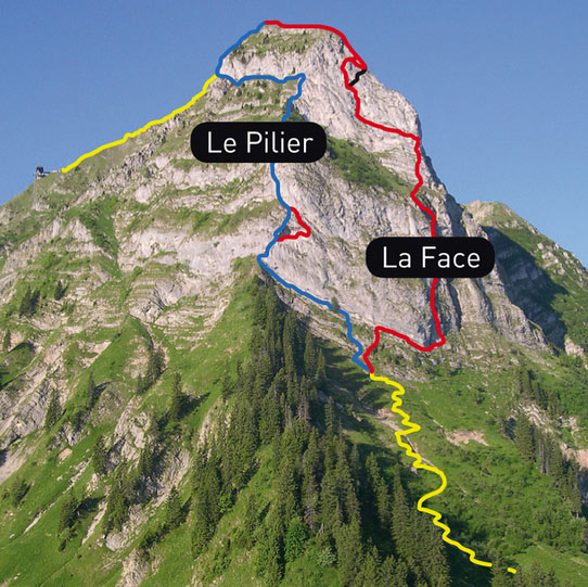
514e Via Ferrata Voie Hohl La Face Moleson Fribourg Switzerland
Via Ferrata Voie Hohl, La Face, Moleson, FribourgFerrata Voie Hohl, La Face, Moleson, Fribourg
Footbridge Monkey Bridge Ladder Zipline 0 0 0 Features
Splendid panorama, long, varied. Not for beginners even if the final exit was made easier. In fact, the last overhang, which hung over the rest of the via, was completely taken down because it had the tendancy of creating traffic jams because of those who overestimated their capacities.
Cost: 4 Frs.-- for adults, 2 Frs.-- for children.
ViaFerrata Tips and Tricks
Take a picnic with you. The panorama at the top of the via ferrata is truly something to be savoured and the restaurant accepts picknickers! (buy a drink... they are nice...).
The via is entirely in the shade. Take an extra layer in case it's cold...The Moléson is a superb resort!!! After the via you can enjoy summer sledding,devalkarting, or grass-scootering.
The lifts are open at 9h00. Make sure they are open if you want to take the funicular to get to the via ferrata.
What to eat in this region: the double Gruyère cream with the Gruyère meringues.
Grade
Strength 3 Dizziness 2 Type High Mountain: 2 Technics 1 Evaluation Very Difficult Information
Office du Tourisme de Moléson Gruyère.
Length and Altitude
Length: 1'310 m
Elevation gain: 372 mètres
Start Elevation: 1'630mGPS Coordinates
N 46'33'363
E 007'33'363
Alt. 1'522 m.Time of Year
April - November
Timing
Approach from the end of the funicular line: 20 minutes
Via Ferrata: 2h30
Way back: with the lifts from the summit of the Moléson. On foot, 1h30By Car
A 12 Vevey - Fribourg-Berne, Highway exit: Bulle
At the highway exit, take the first exit of the roundabout (next to the gas station) towards Moléson-Gstaad
Then follow signs for "Le Moléson"By the Train
Go to Bulle and then by bus or train to Gruyère.
From Montreux: Montbovon to the Gruyère train station, then by bus to Moléson-sur-Gruyères.Contact the SBB, for schedules and fares.
Access
Its very easy. At Moléson, park near the start of the Funicular.
From the Moléson-sur-Gruyères parking, go towards Plan-Francey on foot (1h15) or with the funicular (7 min, leaves every 20 min, at...h00,...h20,... h40). (14 Frs.-- there/back)
In Plan Francey you can rent via ferrata equipment.
From Plan-Francey follow the Via Ferrata signs for about 20 min and you will reach the base of the rock face. The route is in the rock face on the right, and not the via ferrata that is found on the ridge on the left.
Via Ferrata
The Via Ferrata traverses the north face of the Moléson, passing by the cross of the Petit Moléson and arriving at the summit of.... try to guess: the Moléson.
This is not a via ferrata for beginners and we always find some fools stuck on the way. Mountains are something to be respected!
The start is fairly simple, and makes for a great warm up. You climb in some beautiful chimneys that are sometimes a bit athletic. The route was wonderfully traced.
You are given the pleasure of a few overhanging sections... and they are a tad bit strenuous. These sections are not very long... and there are always some flatter areas nearby to rest. The closer you get to the summit, the more strenuous it is. A very nice climb in a chimney with a section that works the arms and is a bit more demanding.
The last part is absolutely amazing. Since there were too many fools who came to this via ferrata for an introduction and ended up getting stuck, the last overhang was removed.
The via is really well equipped. At times there is even a bit too much equipment, but you have the opportunity to be in contact with the rock. It's very enjoyable.
For taller people (like the guy writing this right now) its a bit complicated since you are often in overhanging sections.
Way Back
From the summit, you can go down on foot via Tsuatsaux (2h30 to the parking), via the Gros-Plané (1h45 to the parking) or with the cablecar (4 min to the upper train station).
Where to Spend the Night
Contacte the Tourism Office. The Moléson is a really nice resort.
Media
Olivier Buchs Youtube
-
515e Via Ferrata the Pilier, Moléson, Gruyère, Fribourg, Switzerland
Via Ferrata the Pilier Moléson, Gruyère, Fribourg
Footbridge Monkey Bridge Ladder Zipline 0 0 0 0 Features
Splendid panorama, long, varied.
It costs 4.-- Frs. for adults and 2.-- Frs. for children.ViaFerrata Tips and Tricks
Take a picnic with you. The panorama at the top of the via ferrata is truly something to be savoured and the restaurant accepts picknickers! (buy a drink... they are nice...).
The via is entirely in the shade. Bring an extra layer in case the weather is not very warm...
The Moléson is a superb resort!!! After the via you can enjoy summer sledding,devalkarting, or grass-scootering.The lifts are open at 9h00. Make sure they are open if you want to take the funicular to get to the via ferrata.
What to eat in this region: the double Gruyère cream with the Gruyère meringues.
Grade
Strength 2 Dizziness 3 Type High Mountain: 2 Technics 1 Evaluation Difficult Information
Tourism Office Moléson Gruyère.
Length and Altitude
Length: 650 m
Altitude gain: 372 mètres
Start: 1'630m
GPS Coordinates
N 46'33'363
E 007'33'363
Alt. 1'522 m.Time of Year
From spring to autumn.
Timing
Approach from the top of the funicular: 20 minutes
Via Ferrata: 2 hours
Way back: way back with the lifts from the lifts from the summit of Moléson. On foot, 1h30.By Car
A12 Vevey- Fribourg-Bern, Highway exit: Bulle
When you exit the highway, take the first exit of the roundabout (next to the gas station) towards Moléson-Gstaad
Next go to "Le Moléson"By Train
To Bulle and then by bus or train to Gruyère.
Via Montreux: Montbovon to the Gruyères train station, then by bus to Moléson-sur-Gruyères.Contact the SBB, for schedules and fares.
Access
It's very simple. In Moléson, park near the bottom of the funicular.
From the Moléson-sur-Gruyères parking lot, go towards Plan-Francey on foot (1h15) or with the funicular (7 min, leaving every 20 min, at...h00,...h20,...h40). (14.-- Frs. there and back).
In Plan Francey you can rent via ferrata equipment.
In Plan-Francey follow the Via Ferrata signs for about 20 min and you will get to the base of the wall. The via ferrata described in this article is found on the left along the ridge, and is not the one that is on the right in the rock face.
Via Ferrata
Unlike its neighbour to the right which climbs into the rock face, this via ferrata starts strong and finishes in a more relaxed manner.
After a charming traverse of the rock, you arrive to a section that is more exposed and frankly vertiginous and very demanding for your arms. Here, you have a simple equation: Void + Strenuous = for fit via ferraters.
Nevertheless, there is an escape route to avoid this section.The second part is a mish-mash between a grassy (or muddy) section and via ferrata.
Falling rocks are common, be very careful.This version is easier than its neighbour and can be done by beginners, so long as you take the escape route and so long as the void doesn't scare you too much.
It's up to you, if you are in shape and you have experience with via ferratas, its little sister on the left is the "sexier" choice.Way Back
From the top, you can go down on foot via Tsuatsaux (2h30 to the parking lot), via Gros-Plané (1h45 to the parking lot) or with the lifts (4 min to the upper train station).
Where to Spend the Night
Contact the Tourism Office. The Moléson is a really nice resort.
Olivier Buchs Youtube
Media
-
516e Via Ferrata of the Belvedère, Nax, Valais, Switzerland
Via Ferrata of the Belvédère, Nax, Valais
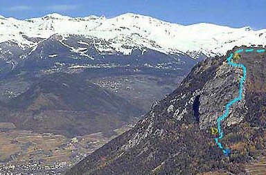
Topo Visinant.ch
Footbridge Monkey Bridge Ladder Zipline 0 2 (but tiny) 0 0 Features
This via ferrata is ideal for beginners and an introduction to via ferratas. The escape route has been canceled. If you stat it, you must finish it till the end
Open all year.
ViaFerrata Tips and Tricks
Bring a picnic for the end of the via, you can climb up on the gazebo (the old end of the via) to make the most of the view. Nax is a nice village.
Grade
Strength 1 Dizziness 2 Type Plaine:2 Technics 2 Evaluation Initiation Information
Tourism office of Nax
Length and Altitude
Length: 450 m
Altitude gain: 220 m
Start: 1'000m
GPS Coordinates
From the beginning of the via:
N 46.13.454
E 007.25.166
Altitude: 995 m.Time of Year
Open all year.
Timing
Aprroach on foot from the parking lot: 5 minutes
Via Ferrata: 1h
Way back: about 25 min back to the parking lotBy Car
From the highway from Martigny take the second exit in Sion (Hospital). Go towards Bramois.
In Bramois cross the bridge over the river and go towards Nax. The via is found about 5km from Bramois. There is a parking lot on the left side of the road in a hairpin and a sign points you to the via ferrata.
By Train
Take the train to Sion. Then the bus to Nax. Contact the SBB for schedules and fares.
Access
From the parking lot follow the small trail in the forest. You will see the sign that welcomes you to the via. Walk a couple minutes more and you arrive at the beginning of the via ferrata.
Via Ferrata
In front of you is the impressive Belvédère cliff: 240 meters of rock, sometimes perfectly vertical
Rules to obey: Never stray from the markings, the numerous ledges are interspersed with projections that are sometimes insurmountable, and the ground can be slippery. You must have the minimum required equipment, that is a helmet (the rock is friable), harness, Y shaped lanyard with a progressive tearing energy absorber, auto-locking carabiners, a rope for children and beginners
The first part of the route is composed of big walls, connected by sequences of ledges and projections. You will cross a small rope bridge (about 3 m), the exit is a bit technical and physical, but nothing too demonic. What's more, there is some void.
You then arrive to a second rope bridge. Make the most of it as the via ferrata ends in a few minutes.
Way Back
Oh! You must go up to the gazebo for the view. Then, take the trail that goes down. The trail is good overall, a bit steep in some places and rock&roll if its humid and rainy.
Where to Spend the Night
ViaFerrata.com Youtube
Photos
-
517e ViaFerrata Loèche, Loèche, Valais, Switzerland
Via Ferrata Loèche, Loèche in Valais
Footbridge Monkey Bridge Ladders Zipline 1 0 +10 0 Features
The longest via ferrata in Switzerland (time)
There are two ferratas to choose from:
- Mieläs-Loèche les Bains, the easiest, with 5 ladders
-Daubenhorn, with an incalculable number of ladders and 6 hours worth of via ferrata.ViaFerrata Tips and Tricks
The probability of receiving a pebble on your head is as high as the expensive cost of the obligatory parking lots in Loèche.
The traditional metal steps in the rock were replaced by some stakes, some nails. If you fall it hurts and you can be skewered. You have been warned.
Stiff hiking boots are necessary to walk on the stakes and for the way down (on the snowfield).
If rain is in the forecast, abandon any plans for climbing because of falling rocks (which in dry weather are already frequent). Personally, I would never bring a child here!
Take at least 1,5 liters of water, for the via is very long.
Park your car at the bottom of the lifts. It is the least expensive parking lot of the resort.
The last lift to go down is at 18h. If you do not want to endure one hour of downhill, leave early in the morning.
Grade for Mielas
Strength 3 Dizziness 4 Type High Mountain / 3 Technics 2 Evaluation Very difficult Grade for Daubenhorn
Strength 4 Dizziness 4 Type High Mountain / 3 Technics 2 Evaluation Extrem Information
Office du Tourisme de Leukerbad
Length and Altitude
Start: 2'060 m
Summit of the Via Ferrata: 2'941 mTime of Year
July to end of September.
Timing
Mieläs-Loèche les Bains; about 5h
Daubenhorn; about 8h, 6 hours of via ferrata, 2h of downhillBy Car
From Geneva take the highway towards Lausanne-Sion. From Chamoix and Aosta go towards Martigny and then towards Sion.
After Sion, continue towards Sierre- La Souste and then zoom zoom towards Brig.
In Susten, go left towards Loèche les Bains, or Leukerbad (over there they speak German)
Drop your car off in front of the Gemmi lifts, it's cheapest and most practical solution. All the parking lots of the resort are paying and are watched with the eyes of a hawk. The debts accumulated by the old big shots of the region have not all been paid off yet!
By Train
Go to Sierre with the train and then take the bus from the train station. Contact the SBB schedules and fares.
Access
De la station du téléphérique (2'346 m) jusqu'à l'ancien chemin de la Gemmi et l'ancienne voie du col après quelques tournants (des rampes partiellement), puis en redescendant jusqu'à la Untere Schmitte où un panneau indique la via ferrata (env. 2060 m), 20 min.
From the lift station (2,346 m) to the old Gemmi trail and the old route for the pass, after a few turns (partially with handrails), and then going down to the Untere Schmitte where a sign points out the via ferrata (about 2060m), 20 min.
Little via ferrata : A well marked trail goes through a first incline, and then starting at a wild cirque flattens out until you reach the first cables of the via.
Via Ferrata Part 1: Mieläs:
You start this jam-packed day with a long traverse between rock and trails. It looks a lot like climbing. You are constantly in contact with the rock. There are few stakes and no steps. You have the option of either clutching the cable or playing with the rock.
Here, a surprise, you will discover the first aldder. You won't need to take a picture, it's not the last one you'll see... this via is a series of ladders!!!
Before getting to the junction of the Daubenhorn via or the junction that allows you to go back down to the Gemmi, 76 m of ladders await you.
Beginning of the 2nd part - The Chimney
You have chosen, then, the most athletic option of the day. This part is fairly dangerous. The void is ever present. A very beautiful section in the cavern is the source of a rather refreshing and relaxing moment, which is much appreciated before attacking a section that is a bit more strenuous and slightly overhanging.
At the summit, take a little break to sign the golden book and then keep going on to the final part.
Be warned! If you eat your munchies here, make sure that you are on the true summit. Some are tricked and believe they are finished when actually...
The last ladder is fairly strenuous, especially because of the fatigue accumulated during the day.
The last part was made longer with the addition of an extra section through a sort of tunnel. This is, however, a physical variant, and you can avoid it.
Way Back
Account for 1h30 to 2h.
Go onto the snowfield and exit on the left at the bottom. The trail is marked with red and white markings.
Where to Spend the Night
Contact the Tourism Office. It's not easy to find a place to catch some zzzzs. There are plenty, but the resort is not very affordable.
Photos
par gmillioud Youtube
par Celine Schlegel Youtube
-
518e Via Ferrata Plan Praz Leysin Vaud Switzerland
Via Ferrata Plan Praz, Leysin, Vaud
Footbridges Monkey Bridges Ladders Zipline 2 x 5m 2 2 1 Features
Following the purest tradition of the new and athletic via ferratas: strenuous and fun.
Not for all hands! Reserved for the best.
Not vertiginous, but demanding!
ViaFerrata Tips and Tricks
A bit hard to find.
If it is too hard for you, give up. Go instead to the Tour d'Ai Via Ferrata in Leysin which is a bit easier.
Difficulty: The first challenge is to find a free parking spot. There is one at the ice-skating rink, but it's a three day walk from here.
Grade
Strength 4 Dizziness 1 Type Mountain: 2 Technics 2 Evaluation Extreme Information
Leysin Tourism Office : we will put the link up when the parking lot issue for via ferrata-ists is resolved.
Length and Altitude
Length: 320 m.
Altitude gain: 150 m.
Time of Year
April to November (when there isn't any snow)
Timing
Approach from the bottom of the lifts: 25 minutes (if you don't get lost)
Via Ferrata: 1h00 to 1h30
Way back to the parking lot: 35 minutes
By Car
From Geneva, take the highway towards Lausanne and then Sion-Martigny. From Chamonix and Aosta go towards Martigny-Suisse. In Martigny take the highway towards Lausanne-Genève. Exit at Aigle (25km).
Once in Aigle, take the N 11 towards Château d'Oex, les Diablerets, Leysin.
By Train
Take the train to Aigle and then to Leysin.
Contact the SBB for train and bus schedules and fares.Access
At the bottom of the lifts, follow the road that goes up (the one on the right).
Be careful if you park your car in the street going up, make sure your car is facing downhill as it is a one way street. This way you won't get a parking ticket.
On your right, you pass by a shelter for trash cans that has a REKA sign. Take the little road going up.
You come to a mini parking lot. From here, go left towards a gray house with green shutters which goes by the gentle name of "A Tout Vent" ("By Any Wind").
Near this house, keep going onto an unpaved trail (straight ahead). You will get to a forest and a pleasant trail climbs up on your right. The via ferrata is not much further, Papa Smurf!
Via Ferrata: in 3 parts
Part 1
Well... it all begins with the most rock&roll section! It starts with a tiltled overhang. It's tough on the arms and is not for all hands. On your way you will discover a rope bridge and a beam that is not so easy to get on.This part is only for the very best, as it is frankly very strenuous.
Part 2
This part is a bit more tranquil, it starts with a grassy and earthen uphill. But since you'll be wearing your sturdy hiking shoes, you won't have any problems.
And bingo, you come across a new overhang that works your arms... It starts to get hard. A nice aerial footbridge in the trees leads you to the last part.
Part 3
With the fatigue you have already accumulated from the first two sections, it gets harder and harder. We'll be brief! Once you see the first ladder, you are there. When you get to the second ladder, your little feet will finally touch the ground. Now you can breathe a sigh of relief!
A guaranteed good time!
Way Back
Like on the way there, but the opposite.
Where to Spend the Night
Camping Semiramis: Tel: +41 24 494 11 48.
Media
-
519e Via Ferrata Allmenalp, Kandersteg, Bern, Switzerland
Via Ferrata Allmenalp, Kandersteg, Bern
Footbridges Monkey Bridge Ladders Ziplines 2 30 m 4 2 Features
Not for everyone. Very technical.
There are stakes instead of the traditional metal steps. Lots of contact with the rock. The stakes can present a certain risk. Be very careful if you want to bring children.
ViaFerrata Tips and Tricks
Pay attention to the weather! It changes very quickly in Kandersteg. If rain is imminent, don't go. The stream can swell very quickly and you will be stuck in the via! We once stayed 2 hours waiting for a thunderstorm to pass and there were many falling rocks.
Hiking shoes with an excellent sole are mandatory!
Grade
Strength 4 Dizziness 4 Type High-Mountain: 3 Technics 3 Evaluation Extreme Information
Office du TourismeKandersteg
Length and Altitude
Altitude gain: 350 m
Start altitude: 1'176 m
Time of Year
June to October (when the lifts are open)
Timing
Approach: 20 minutes
Via Ferrata: 3h00
Way back: with the lifts or 2h on foot.By Car
Go past Bern and continue towards Thun. Then go up towards Kandersteg.
By Train
Go to Thun and then take the bus. Contact the SBB for schedules and fares.
Access
From the Kandersteg train station take the hiking trail that goes towards the valley. Where the Allmibach flows into the Kander, head north to the right of the stream until you get to the starting point at about 1250 m.
From the lower lift station of the Allmenalp, after a farm, cross the river on a bridge.
From the bottom of the lifts, follow the blue and white trail (Klettersteig). Parking is free.
Via Ferrata
The route follows the Allmibach waterfall and the scene is very romantic. Everything starts off with three ladders and a vertiginous climb. Instead of going up traditional steps, you climb on stakes.
It's pretty different from the usual via ferratas and a bit awkward. It's slippery and you must have adequate footwear (tennis shoes and flip flops are prohibited).
You cross over the waterfall via a long footbridge. Here, a path takes you to the next section.
A twisting ladder will make you rotate 180 degrees and you will gain a new perspective on the waterfall. It's very vertiginous, but you remain in contact with the rock along a ridge.
If you are with a guide you can go on the zipline (it is locked, hence, you must have a guide)
You keep climbing and traverse a wooden footbridge and you then have the choice between a zipline or a very vertiginous rope bridge! Going up to the zipline in wet weather is a real challenge. The steps that were put in place have no profile, they are real soapstones. Be careful!
Crossing the monkey bridge is moment of pure intensity! The last part overlooks the entire via and is easier.
Way Back
If you make it before 18h00, the lifts are still open. The restaurant next to the lifts is really nice and the pies are excellent.
If you arrive after 18h00, be prepared for 2 hours of not always well-marked downhill. To get back to the resort, follow the road for 30 minutes and then the yellow signs. If you get lost, tell yourself that you are neither the first nor the last!
Where to Spend the Night
Check with the Tourism Office. Interlaken is really nice and there are several campgrounds.
par Josh Turner Youtube
Media
-
520e Via ferrata San Salvatore, Paradiso, Tessin, Switzerland
Via Ferrata San Salvatore, Lugano, Tessin
Footbridge Monkey Bridge Ladder Zipline 0 0 0 0 Features
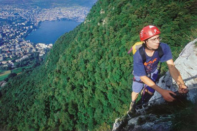
San Salvatore is Lugano's emblematic mountain. This imposing mountain south of the city offers a 360° panorama of the lake, scenery to the south, and the high Alps to the west. It is also know as the "Sugarloaf."
This via ferrata was imported from the Dolomites, that is to say that the rock face is minimally equipped. You will have to be in contact with the rock to climb it.
It's open all year except when there is snow or other inclement weather.
ViaFerrata Tips and Tricks
Make sure you bring your camera, the view on lake Lugano is splendid.
It's a good idea to bring a pair of gloves. And proper shoes too!
Grade
Strength 3 Dizziness 4 Type Mountain: 3 Technics 1 Evaluation Very Difficult Information
Funiculaire Monte San Salvatore
Tourism Office of Lugano
Length and Altitude
Altitude gain: 130 m
Length: 300 m
Start of the via ferrata: 715 m
Top of the via ferrata: 845 mTime of Year
June to October (when the lifts are open)
Timing
Approach: 50 minutes (if you go to the intermediary station on foot)
Via Ferrata: 1h00
Way Back: with the lifts or 2h on foot.By Car
Simply go to Lugano and then towards San Salvatore. The mountain can be seen from anywhere.
By Train
To Lugano. Contact the SBB for schedules and fares.
Access
With the funicular from the start of the Lugano-Paradiso to the Monte San Salvatore.
If you want to go on foot, a marked path leads you to the intermediary funicular station of Pazzallo (490 m) and then to the start of the via ferrata (about 50 minutes).
Via Ferrata
This via ferrata is demanding and only for those who have good biceps. There is a lot of void and very little equipment, so you must use the rock.
To be avoided when its raining and if the rock is wet.
Way Back
At the top of the via ferrata, you can either go frolicking down to Pazzallo on the beautiful path or you can go up to the summit in 20 minutes and from there take the funicular.
Where to Sleep
Check with the Lugano Tourism Office.
par Salvatore Torre Youtube
Media
-
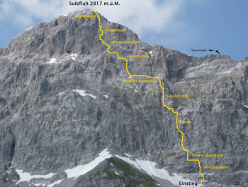
523e Via ferrata Sulzfluh Sankt Antonien, Graubunden, Switzerland
Via Ferrata Sulzfluh Sankt Antonien, Graubünden
Footbridge Monkey Bridge Ladders Zipline 0 1 2 0 Features
Right in the heart of the south face of the Sulfluh. This via ferrata gives you plenty of opportunities to be in contact with the rock. Very vertiginous!
Excellent views and a magnificent panorama. Rock fall possible (always wear a helmet as well as gloves)
ViaFerrata Tips and Tricks
You are in a high mountain setting. Take the necessary precautions as well as all your equipment (rain/wind jacket, warm clothes, excellent shoes).
If you are a beginner, walk away!
Grade
Strength 4 Dizziness 4 Type High Mountain: 2 Technics 1 Evaluation Very difficult
Very long day
Information
Tourism office of St Antonien
Length and Altitude
Parking lot altitude: 1'770 m
Altitude at the start of the Via Ferrata: 2'360 m
End of the via ferrata: 2'817 m
Altitude gain: 450 m
Length: 750 mTime of Year
Mid-June to mid-October (snow).
Timing
Approach
from Partnunstafel St-Antonien: 1 hour 30
from Carschinahütte: 1 hour
from Tilisunahütte: 2 hours 30Way back: 2 hours
By Car
The last Swiss village before the border with Austria in the Ratikon massif. It is also the terminus of the postal bus.
From Chur towards Bad Ragaz. In Landquart, go towards Kublis. In Kublis go up towards Sankt Antonien.
By Train
Contact the SBB. The postal bus goes directly to Sankt Antonien.
Access
From Partnun (1,770 m): Walk to the left of and follow the track suitable for motorized vehicles until you reach the bridge. Follow the path going north-west until you reach the Prattigau panoramic trail.
Climb the steep scree until you reach the the point of attack at the base of the south-east face (2,360m).If you come by bus, the part of the approach on the road is fairly long. Above the houses near Partnun, a bridge crosses a stream bearing the same name. A blue sign points you to the rock-climbing area. From here a trail that gets progressively steeper and rockier leads you to the start of the route.
Via Ferrata
The via ferrata starts off with a short ladder. A dihedral wall then leads you to the Obelix traverse. All of this is followed up with a vertical section and there is no way to back after this and no escape route.
You will discover the Ramp and the Geissrucken which will lead you to a grassy strip (it's important that you wear good hiking shoes - and especially not tennis shoes).
This is where the void will mess with your head. The Panoramica and the Wall of Lamentations are extremely vertiginous and are obstacles that you must overcome. While we're on the topic of overcoming obstacles, you might as well know that next you'll have to get past two rope bridges and a ladder.
After exiting the via ferrata you'll get to the cross (2,817 m) in just 5 minutes.
Way Back
From the summit, find the trail on the north side (be careful, snow sometimes stays until July). Then go down towards the East towards the white and red markings that line the Gemschtobel (the corridor of fallen rocks). The last part made up of terraces and is equipped with chains.
Taking a detour to see the Tilisunahute (about 1 hour) is not only easier on your knees, but allows you to make the most of a beautiful setting.
Where to Spend the Night
Ask the Tourism Office.
par m raegi Youtube
Media
Page 1 of 2


 Topo Visinant.ch