")


Croix de Toulouse
-
15 Via Ferrata Croix de Toulouse, Briancon, Hautes Alpes, France
Via Ferrata Croix de Toulouse Briancon, Hautes Alpes
Passerelle Pont Singe Echelle Tyroliennes 1 x 1 m 0 0 0 Caractéristiques
A conseiller aux débutants et à ceux qui ne veulent pas se faire peur.
 Conseils ViaFerrata
Exposition plein sud, soit la faire le tôt le matin soit prendre à boire, de la crème solaire et des lunettes de soleil.
Très fréquentée en été, mieux vaut éviter certains week-ends.
Cotation
Physique 1 Gaz 2 Type Haute Montagne: 1 Technique 2 Evaluation Pour Débutant, Initiation Information
Office du tourisme de Briançon
 Longueur et Altitude
Départ : 1'290 m
Arrivée 1'962 m
Longueur : 370 m
Dénivelée : + 672 mCoordonnée GPS
Période
Avril à Novembre
Horaire
40 minutes d'approche
Via Ferrata 1 à 2 heures
La descente est raide mais équipée. Compte 40 minutes. Par la route
De Grenoble, prendre la N 91 en direction du col du Lautaret pour atteindre Briançon.
 Par le Train
Voir avec la SNCF: horaires et tarifs
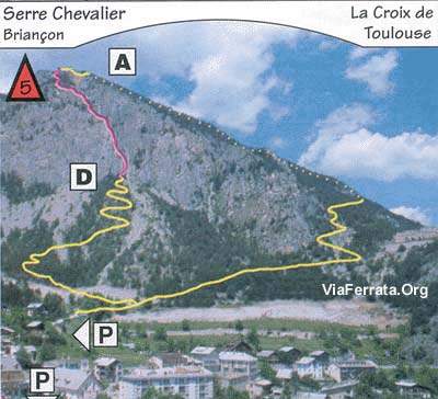
 Accès
AccèsParque ta voiture au parking du Champ de Mars, au-dessus de la cité Vauban. Remonte sur 500m une petite route vers la falaise bien visible, jusqu'à une citerne d'eau (panneau).
Suis un sentier balisé. La via ferrata débute au pied de l'arrête sud-est.
Compte au total 30 min de marche pour atteindre le départ qui se trouve dans un couloir à gauche des voies d'escalades.Via Ferrata
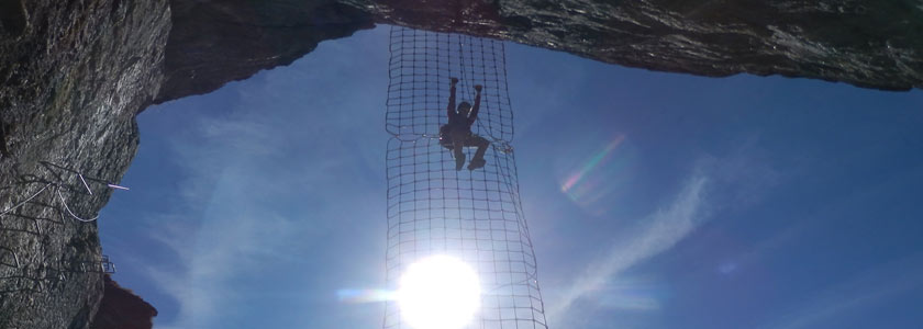
L'itinéraire câblé commence par une série de vires et de petits murs. Quand c'est raide, de nombreux échelons permettent d'être toujours en confiance. Après le premier tiers, c'est la passerelle du Président (au choix le fromage ou celui qui est à Paris). Pas de problème, elle fait un mètre de large et il y a plus impressionnant.
Ensuite tu continues, Briançon à tes pieds, avec pas mal de portions de marche.Un bon casse-croûte au sommet te récompensera de tes efforts. Au retour, tu passes devant le Fort des Salettes et direction le parking.
Retour
Très simple.
 Où dormir
Gîte d'étape du Fontenil
par Chaîne de zebrprod, Youtube
Photos
-
-
15e Via Ferrata Croix de Toulouse, Briancon, Hautes Alpes, France
Via Ferrata Croix de Toulouse, Briancon, Hautes Alpes
Footbridge Monkey Bridge Ladder Zipline 1 x 1m 0 0 0 Features
Recommended for beginners and those who don't want to get scared.
Conseils ViaFerrata Tips and TricksFully south facing, either go early in the morning or bring enough water, sunscreen, and sunglasses.
Very popular during the summer, it's better to avoid certain weekends.
Grade
Strength 1 Dizziness 2 Type High Mountain: 1 Technics 2 Evaluation For Beginner, Initiation Information
Length and AltitudeStart : 1,290 m
End: 1,962 m
Length : 370 m
Elevation gain : + 672 mTime of Year
April to when the snow starts to fall.
Timing
40 minutes of approach
Via Ferrata: 1 to 2 hours
The way down is steep but equipped. About 40 minutes.By CarFrom Grenoble take N91 towards the Lautaret pass to get to Briançon.
By TrainCheck with the SNCF: schedules and fares
AccessPark your car in the Champ de Mars parking lot, above the city of Vauban. Go up 500m on a small road near the very visible cliff face until you reach a water tank (sign).
Follow a marked trail. The via ferrata starts at the base of the south-east arrête.
It takes about 30 minutes to walk to the start which is found in a couloir to the left of the climbing routes.Via Ferrata
The cabled itinerary starts off with a series of ledges and little walls. When it's steep there are always more than enough rungs to keep you at ease. After the first third you go across the President's footbridge (your choice- the brand of cheese or the one in Paris). No problem, it's a meter wide and much scarier sections exist in the world of via ferratas.
Then you keep going with Briançon beneath you, there are quite a few walking sections.A good snack at the top will reward you for your efforts. On the way back you pass by the Salettes Fort and then continue on towards the parking.
Way Back
Very simple.
Where to Spend the NightMedia
par Chaîne de zebrprod, Youtube
-


