")


Sankt Antonien
-
523 Via ferrata Sulzfluh, Sankt Antonien, Grisons, Suisse
Via ferrata Sulzfluh Sankt Antonien, Les Grisons
Passerelle Pont Singe Echelles Tyrolienne 0 1 2 0 Caractéristiques
En plein sud de la face du Sulfluh. Cette via ferrata te donne l'occasion d'être en contact avec le rocher. Très aérienne!
Excellente vue et panorama grandiose. Possible chutes de pierres (porte toujours votre casque ainsi que des gants)
 Conseils ViaFerrata
Tu es en haute montagne. Prends les précautions d'usage ainsi que ton matos complet (veste pluie et vent, habits chauds, excellente chaussures)
Si tu es un débutant, passe ton chemin!
Cotation
Physique 4 Gaz 4 Type Haute Montagne: 2 Technique 1 Evaluation Très difficile. Exigeante!
Très longue journée en haute montagne
Information
Office du Tourisme de St Antonien
 Longueur et Altitude
Départ du Parking: 1'770 m
Départ de la Via Ferrata: 2'360 m
Sommet de la via ferrata: 2'817 m
Dénivelé: 450 m
Longueur: 750 mCoordonnée GPS
Période
Mi-juin à mi-Octobre (neige).
Horaire
Approche
depuis Partnunstafel St-Antonien: 1 heure 30
depuis Carschinahütte: 1 heure
depuis Tilisunahütte: 2 heures 30Retour: 2 heures
 Par la route
Le dernier village Suisse avant la frontière avec l'Autriche dans le massif du Ratikon. C'est également le terminus du Car Postal.
De Chur en direction de Bad Ragaz. A Landquart, prends en direction de Kublis. A Kublis montez en direction de Sankt Antonien.
 Par le Train
Contacte les CFF. Le car postal va directement à Sankt Antonien
 Accès
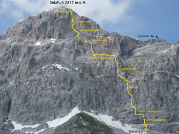
AccèsDe Partnun (1'770 m): Tu longes la piste carrossable sur sa gauche jusqu'au pont. Suis le sentier vers le nord-ouest jusqu'au chemin panoramique du Prattigau. Monte l'éboulis raide afin de rejoindre l'attaque au pied de la paroi sud-est (2'360 m)
Si tu arrives en bus, la marche d’approche sur la route est assez longue. Au-dessus des maisons près de Partnun, un pont traverse le ruisseau du même nom. Un panneau bleu indique la direction du parcours d’escalade. Depuis là, un chemin de plus en plus pentu et caillouteux mène au départ du parcours.
Via Ferrata
La Via ferrata débute par une échelle courte. Un dièdre mène ensuite à la traversée Obelix. Le tout est suivi par un passage vertical et plus moyen de faire demi-tour et il n'y a plus d'échappatoire.
Tu vas découvrir la Rampe et le Geissrucken pour atteindre une large bande herbeuse (importance d'avoir d'excellentes chaussures de montagne - surtout pas de basket).
C'est ici que le gaz va te monter à la tête. Le Panoramica et le Mur des Lamentations sont hyper aériens et sont autant d'obstacles à franchir.
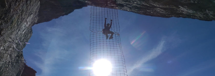
Puisque nous parlons de franchir, c'est ce que tu vas faire sur deux ponts soit de corde et d'une échelle.Depuis la sortie, en 5 petites minutes, tu arrives à la Croix 2'817 m
Retour
Du sommet, gagne le sentier du côté nord (attention, il se peut qu'il y a de la neige jusqu'en juillet). Puis descende vers l'Est en suivant le marquage Blanc-Rouge qui jalonne le Gemschtobel (couloir d'éboulis). La dernière partie forme un gradin qui est sécurisée par des chaînes.
Le détour par la Tilisunahute (compte 1 heure) permet de ménager tes genoux tout en évoluant dans un cadre magnifique.
 Où dormir
Voir avec l'Office du Tourisme.
par m raegi Youtube
Photos
-
-
523e Via ferrata Sulzfluh Sankt Antonien, Graubunden, Switzerland
Via Ferrata Sulzfluh Sankt Antonien, Graubünden
Footbridge Monkey Bridge Ladders Zipline 0 1 2 0 Features
Right in the heart of the south face of the Sulfluh. This via ferrata gives you plenty of opportunities to be in contact with the rock. Very vertiginous!
Excellent views and a magnificent panorama. Rock fall possible (always wear a helmet as well as gloves)
ViaFerrata Tips and TricksYou are in a high mountain setting. Take the necessary precautions as well as all your equipment (rain/wind jacket, warm clothes, excellent shoes).
If you are a beginner, walk away!
Grade
Strength 4 Dizziness 4 Type High Mountain: 2 Technics 1 Evaluation Very difficult
Very long day
Information
Tourism office of St Antonien
Length and AltitudeParking lot altitude: 1'770 m
Altitude at the start of the Via Ferrata: 2'360 m
End of the via ferrata: 2'817 m
Altitude gain: 450 m
Length: 750 mTime of Year
Mid-June to mid-October (snow).
Timing
Approach
from Partnunstafel St-Antonien: 1 hour 30
from Carschinahütte: 1 hour
from Tilisunahütte: 2 hours 30Way back: 2 hours
By CarThe last Swiss village before the border with Austria in the Ratikon massif. It is also the terminus of the postal bus.
From Chur towards Bad Ragaz. In Landquart, go towards Kublis. In Kublis go up towards Sankt Antonien.
By TrainContact the SBB. The postal bus goes directly to Sankt Antonien.
AccessFrom Partnun (1,770 m): Walk to the left of and follow the track suitable for motorized vehicles until you reach the bridge. Follow the path going north-west until you reach the Prattigau panoramic trail.
Climb the steep scree until you reach the the point of attack at the base of the south-east face (2,360m).If you come by bus, the part of the approach on the road is fairly long. Above the houses near Partnun, a bridge crosses a stream bearing the same name. A blue sign points you to the rock-climbing area. From here a trail that gets progressively steeper and rockier leads you to the start of the route.
Via Ferrata
The via ferrata starts off with a short ladder. A dihedral wall then leads you to the Obelix traverse. All of this is followed up with a vertical section and there is no way to back after this and no escape route.
You will discover the Ramp and the Geissrucken which will lead you to a grassy strip (it's important that you wear good hiking shoes - and especially not tennis shoes).
This is where the void will mess with your head. The Panoramica and the Wall of Lamentations are extremely vertiginous and are obstacles that you must overcome. While we're on the topic of overcoming obstacles, you might as well know that next you'll have to get past two rope bridges and a ladder.
After exiting the via ferrata you'll get to the cross (2,817 m) in just 5 minutes.
Way Back
From the summit, find the trail on the north side (be careful, snow sometimes stays until July). Then go down towards the East towards the white and red markings that line the Gemschtobel (the corridor of fallen rocks). The last part made up of terraces and is equipped with chains.
Taking a detour to see the Tilisunahute (about 1 hour) is not only easier on your knees, but allows you to make the most of a beautiful setting.
Where to Spend the NightAsk the Tourism Office.
par m raegi Youtube
Media
-


