grand bornand
-
03 Via Ferrata Tour de Jalouvre, Grand Bornand, Haute-Savoie, France
03 Tour de Jalouvre, Grand Bornand, Haute-Savoie, France

Passerelle Pont de bois Echelle Tyrolienne 1 1 0 0 Caractéristiques
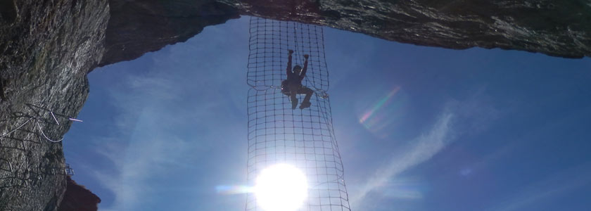
Calcaire, exposée en plein Ouest. Bien intégrée au site, peu de barreaux et une passerelle très spectaculaire à 80 m du sol
Elle se caractérise par une ambiance à la fois aérienne et minérale.
 Conseils ViaFerrata
En hiver, cette via ferrata est systématiquement fermée en raison des problèmes de neiges. Les câbles sont enlevés sur une partie de la via à cause des avalanches. En début de saison, renseigne-toi auprès de l'Office du Tourisme pour savoir si elle est ouverte.
Le niveau de difficulté est lié essentiellement à la longueur importante de la via. L'engagement représenté après le franchissement de la passerelle et le retour pouvant être délicat en début de saison.
Cotation
Physique 3 Gaz 4 Type Haute Montagne: 2 Technique 2 Evaluation Très Difficile Information
Office du tourisme du Grand-Bornand
 Longueur et Altitude
Exposition: Sud-Ouest - Longueur : 1100 m
Dénivellation Via Ferrata : 450 m
Altitude sommet Via Ferrata : 2000 m
Altitude départ Via Ferrata : 1410 m
Dénivellation totale: 590 mCoordonnée GPS
Période
Ouverte de Juin à Novembre
Horaire
Accès: 20-30 minutes
Viaferrata : 3h30 à 4h30 heures.
Retour : 1 heure Par la route
Depuis le Chinaillon, suivre la direction Col de la Colombière. Le curseur sur la carte est mis au départ.
 Par le Train ou le Bus
Alors là... c'est pas dans la poche. Voir avec la SNCF: horaires et tarifs.

 Accès
AccèsLe départ de la marche d'approche se situe à partir du panneau en bordure de route. Après 20 à 30 minutes, tu abordes la première partie de la via par un cheminement en traversée.
Via Ferrata
Une succession de terrasses en bon rocher t'amènent à l'arche du Bouquetin avant le passage clé, constitué par un léger dévers, franchi par petits échelons, imposant des gestes s'apparentant à ceux de l'escalade ; c'est le dévers du"cul tourné". Ca ne s'invente pas...
Après une montée rocheuse, puis un cheminement facile, on traverse en direction de la Tour. Tu peux interrompre cette expérience de via par la "sortie à Fred", empruntant une vire commode puis une courte descente sur échelons.
L'accès à la Tour s'effectue par la passerelle du Gypaète de 16m de longueur, très aérienne, dominée par un beau pilier raide que l'on franchit avec de très fortes sensations : c'est "le pilier des courants d'air". Une grande traversée rocheuse bordant la face, ponctuée par une passerelle sur un demi-tronc de mélèze, peut te créer quelques émotions.Une grande arête facile et esthétique donne ensuite accès au sommet de la Tour.
Retour
Il s'effectue d'abord par une grande traversée dans la face du Jalouvre, au bout laquelle tu parviens à un couloir raide équipé d'un câble pour arriver à la combe du Rasoir où tu rejoins un bon sentier. C'est assez long et compte une bonne heure. Garde tes forces à la montée pour la descente.
Option
A la sortie de la Via, suis le sentier normal qui passe sous le Lapiaz et qui permet de rejoindre la combe située sous le col du rasoir. Juste avant d'arriver sur la combe, on emprunte à nouveau un petit passage câblé.
A la sortie de celui-ci, sur la gauche, se trouve une grosse inscription peinte en rouge sur le rocher : "Arrête des Bouquetins". Il suffit de suivre le marquage rouge. Pas de grosses difficultés techniques sauf sur la fin où la voie emprunte une longue crête chaotique assez gazeuse. Les personnes impressionnables ou peu sûres d'elles auront intérêt à s'encorder.
Cette voie tombée dans l'oubli a été redécouverte par un Papy du Chinaillon, il y a quelques années, et qui a refait le marquage. Elle vaut le détour en tous cas ! Où dormir
Voir avec l'Office du Tourisme
vidéo par Schorail, Youtube
Photos
-
03e Via Ferrata Tour de Jalouvre, Grand Bornand, Haute-Savoie, France
Tour de Jalouvre, Grand Bornand, Haute-Savoie, France

Footbridge Wood Bridge Ladder Zipline 1 1 0 0 Features
Limestone, completely west-facing. Well integrated into this area, few bars and a spectacular footbridge 80m above the ground.
It is characterized by atmosphere that is at once vertiginous and mineral.
 ViaFerrata Tips and Tricks
During the winter this via ferrata is systematically closed due to problems with the snow. The cables are removed from one section because of avalanches. At the start of the season, check with the Tourism Office to find out if it's open.
The difficulty of this via ferrata stems essentially from its considerable length. Once you cross the footbridge the level of commitment is high and at the beginning of the season the way back can be tricky.
Grade
Strength 3 Dizziness 4 Type High Mountain: 2 Technics 2 Evaluation Very Difficult Information
 Length and Altitude
Exposure: Southwest- Length : 1100 m
Elevation gain of the Via Ferrata : 450 m
Altitude at the top of the Via Ferrata : 2000 m
Altitude at the start of the Via Ferrata : 1410 m
Total elevation gain: 590 mTime of Year
Open from June to November
Timing
Access: 20-30 minutes
Viaferrata : 3h30 to 4h30.
Way back : 1 hour By Car
From le Chinaillon, go towards Col de la Colombière. The pointer on the map is on the start.
 By Train or Bus
Well, it's not so easy. Check with the SNCF: schedules and fares.

 Access
The approach begins at the sign on the side of the road. After 20 to 30 minutes you will reach the first part of the via ferrata by means of a traversing path.
Via Ferrata
A series of terraces made from good quality rock bring you to the Ibex Arch, before the crux which consists of a slight overhang that you negotiate with small rungs, forcing you to use moves that resemble those used in rock climbing; it's the overhang of the "turned back." One does not invent these things...
After a rocky climb, and then an easy progresson, we cross towards the Tour. You can interrupt this via ferrata experience by taking the "Fred exit", by way of a comfortable ledge and then a short downclimb with rungs.
Getting to the Tour is achieved by taking the 16m long Gypaète footbridge, very vertiginous, and dominated by a beautiful steep pillar that one overcomes with much thrill and excitement: it is "The Pillar of Drafts." A big rocky traverse that runs alongside the rock face and is punctuated by a footbridge on a half-larch log may awe and inspire you.
A big, easy, and aesthetic ridge then leads you to the summit of the Tour.
Way Back
The way back starts off with a big traverse in the face of the Jalouvre, at the end of which you come to a steep colouir which is equipped with a cable that leads you to the Rasoir valley where you meet up with a good trail. It is fairly long so account for 1 hour. Save your energy on the way up for the downhill.
Alternative
At the end of the Via, folow the normal path which goes under the lapiez and allows you to meet up with the valley located under the Rasoir pass. Just before getting to the valley you will go on another little cabled section.
At the end of this section, on your left, you will find a big inscription painted in red on the rock: "Arrête des Bouquetins." Follow the red markings. There are no major technical difficulties except towards the end where the route takes you up a long chaotic ridge that is fairly vertiginous. Those who are impressionable or not sure of themselves should rope-up.
This route, which had fallen into oblivion, was rediscovered a couple years ago by a grandpa from Chinaillon who re-did the markings. It's well worth the detour, that's for sure! Where to Sleep
Check with the Tourism Office.
vidéo par Schorail, Youtube
Media


